You are here: Home > Network List > US - United States National Seismic Network Stations List
> Station MSO Missoula, Montana, USA > Earthquake Result Viewer
MSO Missoula, Montana, USA - Earthquake Result Viewer
| Earthquake location: |
Near Coast Of Venezuela |
| Earthquake latitude/longitude: |
10.9/-62.9 |
| Earthquake time(UTC): |
2018/08/21 (233) 21:31:46 GMT |
| Earthquake Depth: |
154 km |
| Earthquake Magnitude: |
7.3 Mww |
| Earthquake Catalog/Contributor: |
NEIC PDE/us |
|
| Network: |
US United States National Seismic Network |
| Station: |
MSO Missoula, Montana, USA |
| Lat/Lon: |
46.83 N/113.94 W |
| Elevation: |
1264 m |
|
| Distance: |
55.9 deg |
| Az: |
319.866 deg |
| Baz: |
112.752 deg |
| Ray Param: |
0.063962065 |
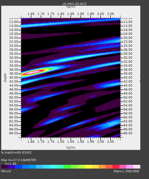
| Estimated Moho Depth: |
37.0 km |
| Estimated Crust Vp/Vs: |
1.66 |
| Assumed Crust Vp: |
6.353 km/s |
| Estimated Crust Vs: |
3.827 km/s |
| Estimated Crust Poisson's Ratio: |
0.22 |
|
| Radial Match: |
94.83401 % |
| Radial Bump: |
400 |
| Transverse Match: |
74.52871 % |
| Transverse Bump: |
400 |
| SOD ConfigId: |
2825771 |
| Insert Time: |
2018-09-04 21:51:43.638 +0000 |
| GWidth: |
2.5 |
| Max Bumps: |
400 |
| Tol: |
0.001 |
|

Signal To Noise
| Channel | StoN | STA | LTA |
| US:MSO:00:BHZ:20180821T21:40:37.499993Z | 35.870415 | 5.0598096E-6 | 1.4105802E-7 |
| US:MSO:00:BH1:20180821T21:40:37.499993Z | 15.501088 | 9.394565E-7 | 6.060584E-8 |
| US:MSO:00:BH2:20180821T21:40:37.499993Z | 17.758966 | 2.1104584E-6 | 1.18839026E-7 |
| Arrivals |
| Ps | 4.1 SECOND |
| PpPs | 15 SECOND |
| PsPs/PpSs | 19 SECOND |


