You are here: Home > Network List > G - GEOSCOPE Stations List
> Station ATD Arta Cave - Arta, Republic of Djibouti > Earthquake Result Viewer
ATD Arta Cave - Arta, Republic of Djibouti - Earthquake Result Viewer
| Earthquake location: |
Luzon, Philippines |
| Earthquake latitude/longitude: |
17.6/120.8 |
| Earthquake time(UTC): |
2022/07/27 (208) 00:43:24 GMT |
| Earthquake Depth: |
10 km |
| Earthquake Magnitude: |
7.0 Mww |
| Earthquake Catalog/Contributor: |
NEIC PDE/us |
|
| Network: |
G GEOSCOPE |
| Station: |
ATD Arta Cave - Arta, Republic of Djibouti |
| Lat/Lon: |
11.53 N/42.85 E |
| Elevation: |
610 m |
|
| Distance: |
75.2 deg |
| Az: |
277.614 deg |
| Baz: |
74.75 deg |
| Ray Param: |
0.05179918 |
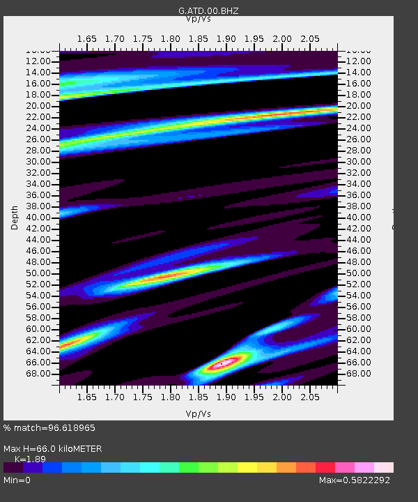
| Estimated Moho Depth: |
66.0 km |
| Estimated Crust Vp/Vs: |
1.89 |
| Assumed Crust Vp: |
6.375 km/s |
| Estimated Crust Vs: |
3.373 km/s |
| Estimated Crust Poisson's Ratio: |
0.31 |
|
| Radial Match: |
96.618965 % |
| Radial Bump: |
295 |
| Transverse Match: |
85.4865 % |
| Transverse Bump: |
400 |
| SOD ConfigId: |
28764291 |
| Insert Time: |
2022-08-10 00:59:59.009 +0000 |
| GWidth: |
2.5 |
| Max Bumps: |
400 |
| Tol: |
0.001 |
|
Signal To Noise
| Channel | StoN | STA | LTA |
| G:ATD:00:BHZ:20220727T00:54:35.949017Z | 8.910326 | 8.473627E-7 | 9.509895E-8 |
| G:ATD:00:BHN:20220727T00:54:35.949017Z | 1.3590384 | 1.3787947E-7 | 1.014537E-7 |
| G:ATD:00:BHE:20220727T00:54:35.949017Z | 3.3170161 | 3.6338017E-7 | 1.0955032E-7 |
| Arrivals |
| Ps | 9.5 SECOND |
| PpPs | 29 SECOND |
| PsPs/PpSs | 39 SECOND |


