You are here: Home > Network List > US - United States National Seismic Network Stations List
> Station WUAZ Wupatki, Arizona, USA > Earthquake Result Viewer
WUAZ Wupatki, Arizona, USA - Earthquake Result Viewer
| Earthquake location: |
Near Coast Of Venezuela |
| Earthquake latitude/longitude: |
10.9/-62.9 |
| Earthquake time(UTC): |
2018/08/21 (233) 21:31:46 GMT |
| Earthquake Depth: |
154 km |
| Earthquake Magnitude: |
7.3 Mww |
| Earthquake Catalog/Contributor: |
NEIC PDE/us |
|
| Network: |
US United States National Seismic Network |
| Station: |
WUAZ Wupatki, Arizona, USA |
| Lat/Lon: |
35.52 N/111.37 W |
| Elevation: |
1592 m |
|
| Distance: |
50.3 deg |
| Az: |
307.395 deg |
| Baz: |
106.928 deg |
| Ray Param: |
0.06763315 |
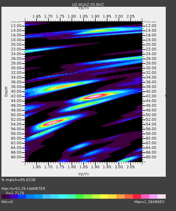
| Estimated Moho Depth: |
53.25 km |
| Estimated Crust Vp/Vs: |
1.71 |
| Assumed Crust Vp: |
6.207 km/s |
| Estimated Crust Vs: |
3.624 km/s |
| Estimated Crust Poisson's Ratio: |
0.24 |
|
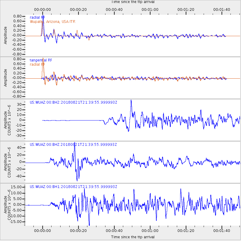
| Radial Match: |
95.8239 % |
| Radial Bump: |
400 |
| Transverse Match: |
87.36198 % |
| Transverse Bump: |
400 |
| SOD ConfigId: |
2825771 |
| Insert Time: |
2018-09-04 21:52:09.356 +0000 |
| GWidth: |
2.5 |
| Max Bumps: |
400 |
| Tol: |
0.001 |
|
Signal To Noise
| Channel | StoN | STA | LTA |
| US:WUAZ:00:BHZ:20180821T21:39:55.999993Z | 23.865124 | 3.6406284E-6 | 1.5255016E-7 |
| US:WUAZ:00:BH1:20180821T21:39:55.999993Z | 10.284968 | 5.03283E-7 | 4.8933835E-8 |
| US:WUAZ:00:BH2:20180821T21:39:55.999993Z | 19.285837 | 1.635233E-6 | 8.478932E-8 |
| Arrivals |
| Ps | 6.5 SECOND |
| PpPs | 22 SECOND |
| PsPs/PpSs | 28 SECOND |


