You are here: Home > Network List > UU - University of Utah Regional Network Stations List
> Station HVU Hansel Valley, UT, USA > Earthquake Result Viewer
HVU Hansel Valley, UT, USA - Earthquake Result Viewer
| Earthquake location: |
Near Coast Of Venezuela |
| Earthquake latitude/longitude: |
10.9/-62.9 |
| Earthquake time(UTC): |
2018/08/21 (233) 21:31:46 GMT |
| Earthquake Depth: |
154 km |
| Earthquake Magnitude: |
7.3 Mww |
| Earthquake Catalog/Contributor: |
NEIC PDE/us |
|
| Network: |
UU University of Utah Regional Network |
| Station: |
HVU Hansel Valley, UT, USA |
| Lat/Lon: |
41.78 N/112.78 W |
| Elevation: |
1609 m |
|
| Distance: |
53.3 deg |
| Az: |
314.487 deg |
| Baz: |
110.447 deg |
| Ray Param: |
0.06565778 |
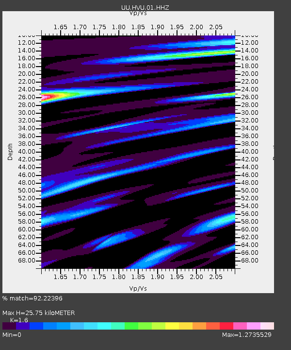
| Estimated Moho Depth: |
25.75 km |
| Estimated Crust Vp/Vs: |
1.60 |
| Assumed Crust Vp: |
6.276 km/s |
| Estimated Crust Vs: |
3.922 km/s |
| Estimated Crust Poisson's Ratio: |
0.18 |
|
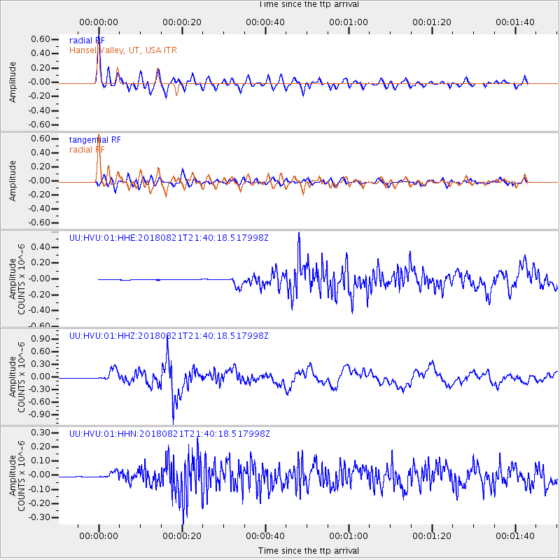
| Radial Match: |
92.22396 % |
| Radial Bump: |
400 |
| Transverse Match: |
84.12086 % |
| Transverse Bump: |
400 |
| SOD ConfigId: |
2825771 |
| Insert Time: |
2018-09-04 21:52:33.967 +0000 |
| GWidth: |
2.5 |
| Max Bumps: |
400 |
| Tol: |
0.001 |
|
Signal To Noise
| Channel | StoN | STA | LTA |
| UU:HVU:01:HHZ:20180821T21:40:18.517998Z | 36.04597 | 1.4370758E-7 | 3.986786E-9 |
| UU:HVU:01:HHN:20180821T21:40:18.517998Z | 13.6058035 | 2.4127644E-8 | 1.7733347E-9 |
| UU:HVU:01:HHE:20180821T21:40:18.517998Z | 23.998133 | 6.5054245E-8 | 2.7108045E-9 |
| Arrivals |
| Ps | 2.6 SECOND |
| PpPs | 10 SECOND |
| PsPs/PpSs | 13 SECOND |


