You are here: Home > Network List > UW - Pacific Northwest Regional Seismic Network Stations List
> Station PASS Maple Falls, WA, USA > Earthquake Result Viewer
PASS Maple Falls, WA, USA - Earthquake Result Viewer
| Earthquake location: |
Luzon, Philippines |
| Earthquake latitude/longitude: |
17.6/120.8 |
| Earthquake time(UTC): |
2022/07/27 (208) 00:43:24 GMT |
| Earthquake Depth: |
10 km |
| Earthquake Magnitude: |
7.0 Mww |
| Earthquake Catalog/Contributor: |
NEIC PDE/us |
|
| Network: |
UW Pacific Northwest Regional Seismic Network |
| Station: |
PASS Maple Falls, WA, USA |
| Lat/Lon: |
49.00 N/122.09 W |
| Elevation: |
174 m |
|
| Distance: |
93.5 deg |
| Az: |
35.965 deg |
| Baz: |
301.711 deg |
| Ray Param: |
0.041259147 |
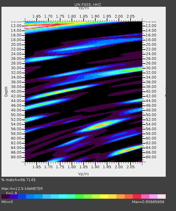
| Estimated Moho Depth: |
12.5 km |
| Estimated Crust Vp/Vs: |
1.60 |
| Assumed Crust Vp: |
6.566 km/s |
| Estimated Crust Vs: |
4.104 km/s |
| Estimated Crust Poisson's Ratio: |
0.18 |
|
| Radial Match: |
86.7145 % |
| Radial Bump: |
400 |
| Transverse Match: |
76.601036 % |
| Transverse Bump: |
400 |
| SOD ConfigId: |
28764291 |
| Insert Time: |
2022-08-10 01:12:06.148 +0000 |
| GWidth: |
2.5 |
| Max Bumps: |
400 |
| Tol: |
0.001 |
|
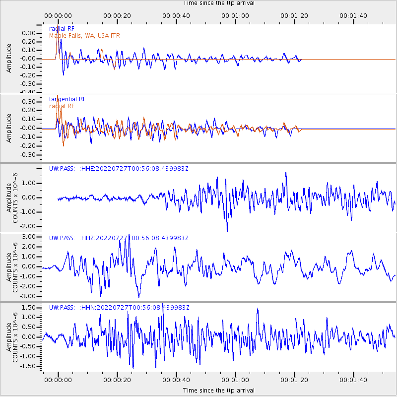
Signal To Noise
| Channel | StoN | STA | LTA |
| UW:PASS: :HHZ:20220727T00:56:08.439983Z | 6.23547 | 6.7743827E-7 | 1.086427E-7 |
| UW:PASS: :HHN:20220727T00:56:08.439983Z | 2.3836708 | 2.0976042E-7 | 8.7998906E-8 |
| UW:PASS: :HHE:20220727T00:56:08.439983Z | 2.3564465 | 2.0017332E-7 | 8.494712E-8 |
| Arrivals |
| Ps | 1.2 SECOND |
| PpPs | 4.8 SECOND |
| PsPs/PpSs | 6.0 SECOND |


