You are here: Home > Network List > AV - Alaska Volcano Observatory Stations List
> Station GAEA East, Gareloi Volcano, Alaska > Earthquake Result Viewer
GAEA East, Gareloi Volcano, Alaska - Earthquake Result Viewer
| Earthquake location: |
Tonga Islands |
| Earthquake latitude/longitude: |
-18.7/-173.9 |
| Earthquake time(UTC): |
2022/07/27 (208) 09:36:51 GMT |
| Earthquake Depth: |
10 km |
| Earthquake Magnitude: |
5.6 Mww |
| Earthquake Catalog/Contributor: |
NEIC PDE/us |
|
| Network: |
AV Alaska Volcano Observatory |
| Station: |
GAEA East, Gareloi Volcano, Alaska |
| Lat/Lon: |
51.78 N/178.75 W |
| Elevation: |
326 m |
|
| Distance: |
70.3 deg |
| Az: |
356.772 deg |
| Baz: |
175.072 deg |
| Ray Param: |
0.05506694 |
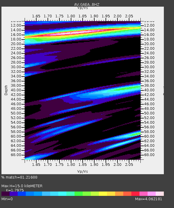
| Estimated Moho Depth: |
15.0 km |
| Estimated Crust Vp/Vs: |
1.80 |
| Assumed Crust Vp: |
6.048 km/s |
| Estimated Crust Vs: |
3.365 km/s |
| Estimated Crust Poisson's Ratio: |
0.28 |
|
| Radial Match: |
81.21688 % |
| Radial Bump: |
400 |
| Transverse Match: |
82.55182 % |
| Transverse Bump: |
400 |
| SOD ConfigId: |
28764291 |
| Insert Time: |
2022-08-10 09:43:50.884 +0000 |
| GWidth: |
2.5 |
| Max Bumps: |
400 |
| Tol: |
0.001 |
|

Signal To Noise
| Channel | StoN | STA | LTA |
| AV:GAEA: :BHZ:20220727T09:47:33.579981Z | 1.0666997 | 1.119898E-6 | 1.0498718E-6 |
| AV:GAEA: :BHN:20220727T09:47:33.579981Z | 1.0377952 | 2.01974E-6 | 1.9461836E-6 |
| AV:GAEA: :BHE:20220727T09:47:33.579981Z | 1.0610505 | 2.231725E-6 | 2.1033165E-6 |
| Arrivals |
| Ps | 2.0 SECOND |
| PpPs | 6.7 SECOND |
| PsPs/PpSs | 8.8 SECOND |


