You are here: Home > Network List > UU - University of Utah Regional Network Stations List
> Station GAWY Genesis Alkali Granger, WY, USA > Earthquake Result Viewer
GAWY Genesis Alkali Granger, WY, USA - Earthquake Result Viewer
| Earthquake location: |
Near Coast Of Venezuela |
| Earthquake latitude/longitude: |
10.9/-62.9 |
| Earthquake time(UTC): |
2018/08/21 (233) 21:31:46 GMT |
| Earthquake Depth: |
154 km |
| Earthquake Magnitude: |
7.3 Mww |
| Earthquake Catalog/Contributor: |
NEIC PDE/us |
|
| Network: |
UU University of Utah Regional Network |
| Station: |
GAWY Genesis Alkali Granger, WY, USA |
| Lat/Lon: |
41.74 N/109.85 W |
| Elevation: |
2011 m |
|
| Distance: |
51.3 deg |
| Az: |
315.464 deg |
| Baz: |
112.985 deg |
| Ray Param: |
0.06699078 |
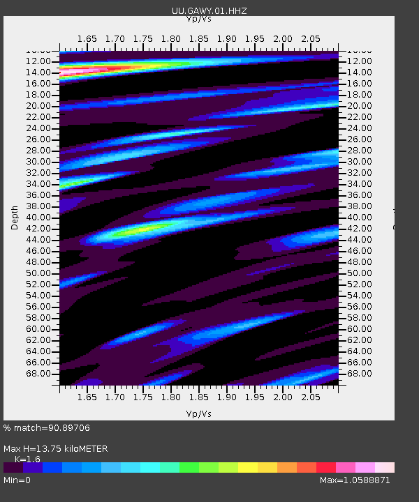
| Estimated Moho Depth: |
13.75 km |
| Estimated Crust Vp/Vs: |
1.60 |
| Assumed Crust Vp: |
6.207 km/s |
| Estimated Crust Vs: |
3.879 km/s |
| Estimated Crust Poisson's Ratio: |
0.18 |
|
| Radial Match: |
90.89706 % |
| Radial Bump: |
400 |
| Transverse Match: |
70.345665 % |
| Transverse Bump: |
400 |
| SOD ConfigId: |
2825771 |
| Insert Time: |
2018-09-04 21:54:13.694 +0000 |
| GWidth: |
2.5 |
| Max Bumps: |
400 |
| Tol: |
0.001 |
|

Signal To Noise
| Channel | StoN | STA | LTA |
| UU:GAWY:01:HHZ:20180821T21:40:03.469994Z | 47.97385 | 2.47358E-7 | 5.156101E-9 |
| UU:GAWY:01:HHN:20180821T21:40:03.469994Z | 5.653781 | 2.050485E-8 | 3.6267498E-9 |
| UU:GAWY:01:HHE:20180821T21:40:03.469994Z | 22.762108 | 1.0244444E-7 | 4.500657E-9 |
| Arrivals |
| Ps | 1.4 SECOND |
| PpPs | 5.4 SECOND |
| PsPs/PpSs | 6.8 SECOND |


