You are here: Home > Network List > AV - Alaska Volcano Observatory Stations List
> Station MAPS Pakushin Southeast, Makushin Volcano, Alaska > Earthquake Result Viewer
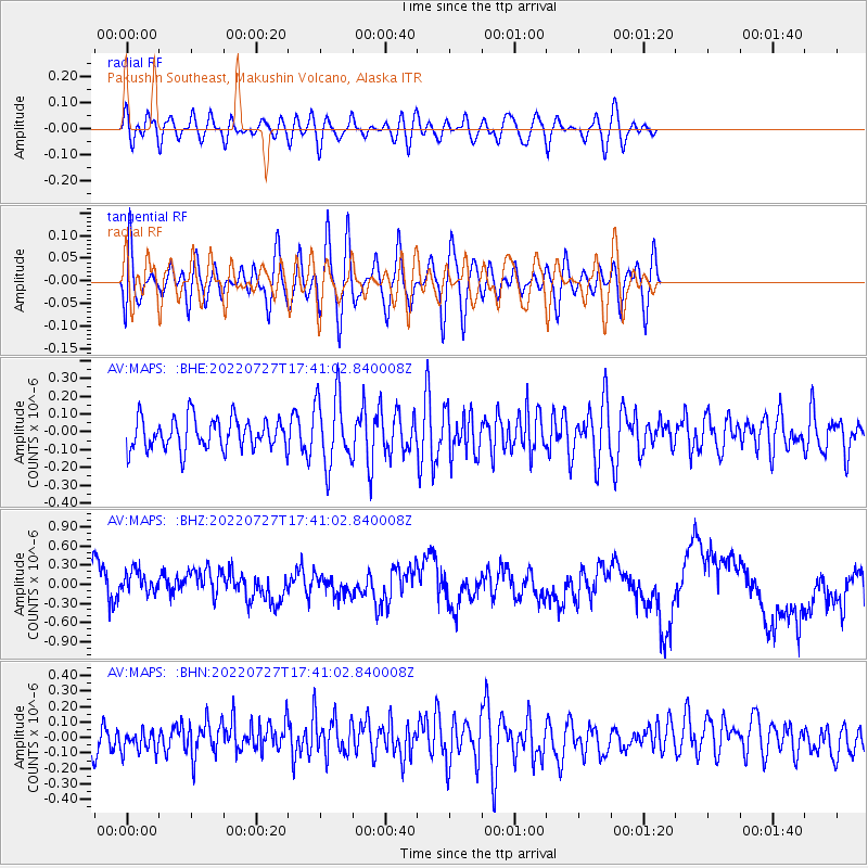
MAPS Pakushin Southeast, Makushin Volcano, Alaska - Earthquake Result Viewer
*The percent match for this event was below the threshold and hence no stack was calculated.
| Earthquake location: |
South Of Fiji Islands |
| Earthquake latitude/longitude: |
-26.9/-176.4 |
| Earthquake time(UTC): |
2022/07/27 (208) 17:29:20 GMT |
| Earthquake Depth: |
10 km |
| Earthquake Magnitude: |
5.5 mww |
| Earthquake Catalog/Contributor: |
NEIC PDE/us |
|
| Network: |
AV Alaska Volcano Observatory |
| Station: |
MAPS Pakushin Southeast, Makushin Volcano, Alaska |
| Lat/Lon: |
53.81 N/166.94 W |
| Elevation: |
333 m |
|
| Distance: |
80.8 deg |
| Az: |
5.676 deg |
| Baz: |
188.562 deg |
| Ray Param: |
$rayparam |
*The percent match for this event was below the threshold and hence was not used in the summary stack. |
|
| Radial Match: |
44.614582 % |
| Radial Bump: |
400 |
| Transverse Match: |
43.376373 % |
| Transverse Bump: |
400 |
| SOD ConfigId: |
28764291 |
| Insert Time: |
2022-08-10 17:37:31.671 +0000 |
| GWidth: |
2.5 |
| Max Bumps: |
400 |
| Tol: |
0.001 |
|
Signal To Noise
| Channel | StoN | STA | LTA |
| AV:MAPS: :BHZ:20220727T17:41:02.840008Z | 1.0092579 | 2.9815678E-7 | 2.9542178E-7 |
| AV:MAPS: :BHN:20220727T17:41:02.840008Z | 0.6725954 | 7.2841E-8 | 1.08298394E-7 |
| AV:MAPS: :BHE:20220727T17:41:02.840008Z | 2.2394185 | 1.9719582E-7 | 8.80567E-8 |
| Arrivals |
| Ps | |
| PpPs | |
| PsPs/PpSs | |


