You are here: Home > Network List > TX - Texas Seismological Network Stations List
> Station MB05 Klondike > Earthquake Result Viewer
MB05 Klondike - Earthquake Result Viewer
| Earthquake location: |
South Of Fiji Islands |
| Earthquake latitude/longitude: |
-26.9/-176.4 |
| Earthquake time(UTC): |
2022/07/27 (208) 17:29:20 GMT |
| Earthquake Depth: |
10 km |
| Earthquake Magnitude: |
5.5 mww |
| Earthquake Catalog/Contributor: |
NEIC PDE/us |
|
| Network: |
TX Texas Seismological Network |
| Station: |
MB05 Klondike |
| Lat/Lon: |
32.63 N/101.86 W |
| Elevation: |
882 m |
|
| Distance: |
92.4 deg |
| Az: |
54.495 deg |
| Baz: |
239.454 deg |
| Ray Param: |
0.04147134 |
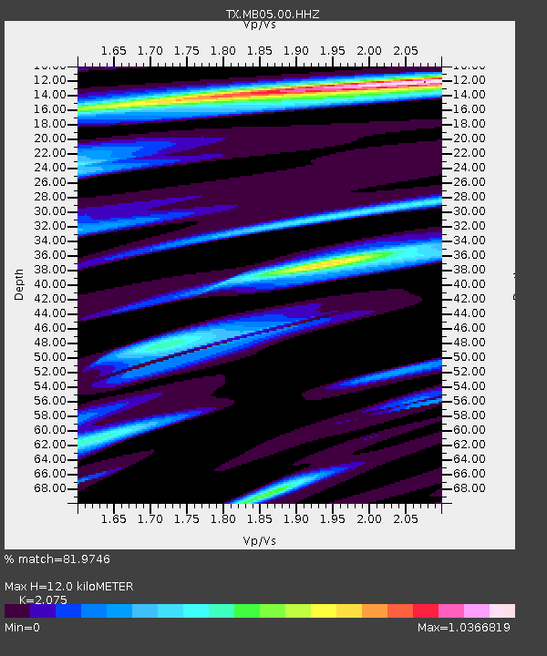
| Estimated Moho Depth: |
12.0 km |
| Estimated Crust Vp/Vs: |
2.08 |
| Assumed Crust Vp: |
6.426 km/s |
| Estimated Crust Vs: |
3.097 km/s |
| Estimated Crust Poisson's Ratio: |
0.35 |
|
| Radial Match: |
81.9746 % |
| Radial Bump: |
339 |
| Transverse Match: |
74.01395 % |
| Transverse Bump: |
354 |
| SOD ConfigId: |
28764291 |
| Insert Time: |
2022-08-10 17:52:17.700 +0000 |
| GWidth: |
2.5 |
| Max Bumps: |
400 |
| Tol: |
0.001 |
|

Signal To Noise
| Channel | StoN | STA | LTA |
| TX:MB05:00:HHZ:20220727T17:41:59.309979Z | 1.275415 | 2.601684E-8 | 2.0398724E-8 |
| TX:MB05:00:HH1:20220727T17:41:59.309979Z | 0.62764245 | 8.537501E-9 | 1.3602492E-8 |
| TX:MB05:00:HH2:20220727T17:41:59.309979Z | 2.0353336 | 2.2075318E-8 | 1.0846044E-8 |
| Arrivals |
| Ps | 2.0 SECOND |
| PpPs | 5.6 SECOND |
| PsPs/PpSs | 7.7 SECOND |


