You are here: Home > Network List > UU - University of Utah Regional Network Stations List
> Station CCUT Cedar City, UT, USA > Earthquake Result Viewer
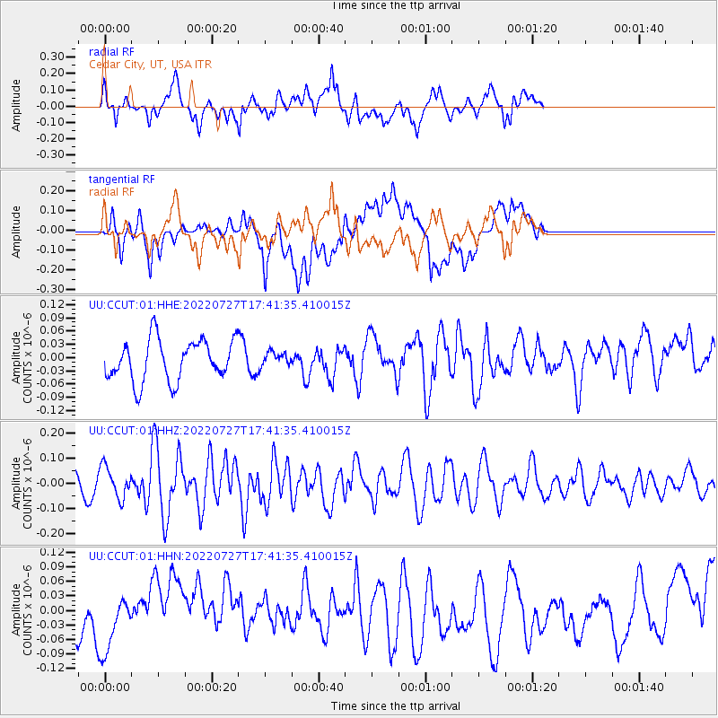
CCUT Cedar City, UT, USA - Earthquake Result Viewer
*The percent match for this event was below the threshold and hence no stack was calculated.
| Earthquake location: |
South Of Fiji Islands |
| Earthquake latitude/longitude: |
-26.9/-176.4 |
| Earthquake time(UTC): |
2022/07/27 (208) 17:29:20 GMT |
| Earthquake Depth: |
10 km |
| Earthquake Magnitude: |
5.5 mww |
| Earthquake Catalog/Contributor: |
NEIC PDE/us |
|
| Network: |
UU University of Utah Regional Network |
| Station: |
CCUT Cedar City, UT, USA |
| Lat/Lon: |
37.55 N/113.36 W |
| Elevation: |
2127 m |
|
| Distance: |
87.2 deg |
| Az: |
45.179 deg |
| Baz: |
232.818 deg |
| Ray Param: |
$rayparam |
*The percent match for this event was below the threshold and hence was not used in the summary stack. |
|
| Radial Match: |
68.27628 % |
| Radial Bump: |
400 |
| Transverse Match: |
41.919567 % |
| Transverse Bump: |
400 |
| SOD ConfigId: |
28764291 |
| Insert Time: |
2022-08-10 17:53:46.019 +0000 |
| GWidth: |
2.5 |
| Max Bumps: |
400 |
| Tol: |
0.001 |
|
Signal To Noise
| Channel | StoN | STA | LTA |
| UU:CCUT:01:HHZ:20220727T17:41:35.410015Z | 1.5649855 | 6.19609E-8 | 3.9591995E-8 |
| UU:CCUT:01:HHN:20220727T17:41:35.410015Z | 1.3691695 | 5.672303E-8 | 4.1428788E-8 |
| UU:CCUT:01:HHE:20220727T17:41:35.410015Z | 0.34479427 | 1.5942929E-8 | 4.623896E-8 |
| Arrivals |
| Ps | |
| PpPs | |
| PsPs/PpSs | |


