You are here: Home > Network List > UW - Pacific Northwest Regional Seismic Network Stations List
> Station UMAT Pilot Rock, OR, USA > Earthquake Result Viewer
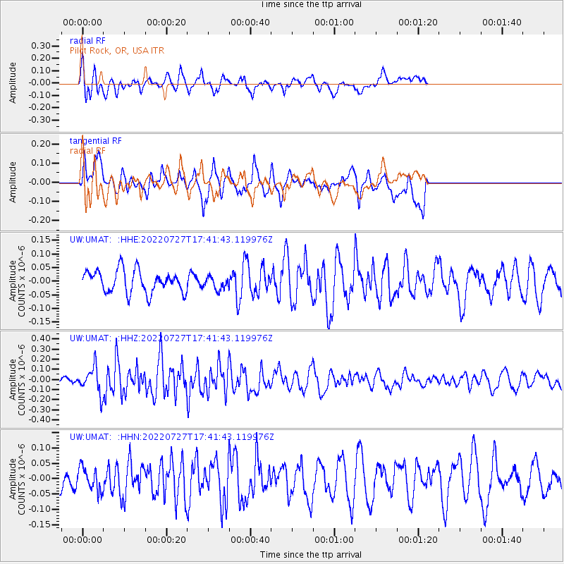
UMAT Pilot Rock, OR, USA - Earthquake Result Viewer
*The percent match for this event was below the threshold and hence no stack was calculated.
| Earthquake location: |
South Of Fiji Islands |
| Earthquake latitude/longitude: |
-26.9/-176.4 |
| Earthquake time(UTC): |
2022/07/27 (208) 17:29:20 GMT |
| Earthquake Depth: |
10 km |
| Earthquake Magnitude: |
5.5 mww |
| Earthquake Catalog/Contributor: |
NEIC PDE/us |
|
| Network: |
UW Pacific Northwest Regional Seismic Network |
| Station: |
UMAT Pilot Rock, OR, USA |
| Lat/Lon: |
45.29 N/118.96 W |
| Elevation: |
1318 m |
|
| Distance: |
88.9 deg |
| Az: |
36.525 deg |
| Baz: |
228.825 deg |
| Ray Param: |
$rayparam |
*The percent match for this event was below the threshold and hence was not used in the summary stack. |
|
| Radial Match: |
52.824036 % |
| Radial Bump: |
400 |
| Transverse Match: |
50.90218 % |
| Transverse Bump: |
400 |
| SOD ConfigId: |
28764291 |
| Insert Time: |
2022-08-10 17:54:58.770 +0000 |
| GWidth: |
2.5 |
| Max Bumps: |
400 |
| Tol: |
0.001 |
|
Signal To Noise
| Channel | StoN | STA | LTA |
| UW:UMAT: :HHZ:20220727T17:41:43.119976Z | 2.4863498 | 1.3380667E-7 | 5.381651E-8 |
| UW:UMAT: :HHN:20220727T17:41:43.119976Z | 0.6403164 | 3.8213344E-8 | 5.967884E-8 |
| UW:UMAT: :HHE:20220727T17:41:43.119976Z | 0.57121235 | 2.3361409E-8 | 4.089794E-8 |
| Arrivals |
| Ps | |
| PpPs | |
| PsPs/PpSs | |


