You are here: Home > Network List > GM - US Geological Survey Networks Stations List
> Station NMP31 New Mexico Permian - Site# W3S1 > Earthquake Result Viewer
NMP31 New Mexico Permian - Site# W3S1 - Earthquake Result Viewer
| Earthquake location: |
Northern Chile |
| Earthquake latitude/longitude: |
-22.2/-68.5 |
| Earthquake time(UTC): |
2022/07/27 (208) 18:58:57 GMT |
| Earthquake Depth: |
97 km |
| Earthquake Magnitude: |
6.2 Mww |
| Earthquake Catalog/Contributor: |
NEIC PDE/us |
|
| Network: |
GM US Geological Survey Networks |
| Station: |
NMP31 New Mexico Permian - Site# W3S1 |
| Lat/Lon: |
32.04 N/103.73 W |
| Elevation: |
973 m |
|
| Distance: |
63.6 deg |
| Az: |
326.834 deg |
| Baz: |
143.348 deg |
| Ray Param: |
0.059213337 |
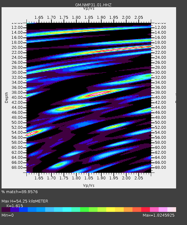
| Estimated Moho Depth: |
54.25 km |
| Estimated Crust Vp/Vs: |
1.62 |
| Assumed Crust Vp: |
6.129 km/s |
| Estimated Crust Vs: |
3.795 km/s |
| Estimated Crust Poisson's Ratio: |
0.19 |
|
| Radial Match: |
89.9576 % |
| Radial Bump: |
400 |
| Transverse Match: |
89.782616 % |
| Transverse Bump: |
400 |
| SOD ConfigId: |
28764291 |
| Insert Time: |
2022-08-10 19:20:20.333 +0000 |
| GWidth: |
2.5 |
| Max Bumps: |
400 |
| Tol: |
0.001 |
|

Signal To Noise
| Channel | StoN | STA | LTA |
| GM:NMP31:01:HHZ:20220727T19:08:47.449979Z | 8.15309 | 1.999368E-6 | 2.4522825E-7 |
| GM:NMP31:01:HHN:20220727T19:08:47.449979Z | 2.8257544 | 5.1788896E-7 | 1.8327457E-7 |
| GM:NMP31:01:HHE:20220727T19:08:47.449979Z | 5.1527796 | 9.0281026E-7 | 1.7520838E-7 |
| Arrivals |
| Ps | 5.7 SECOND |
| PpPs | 22 SECOND |
| PsPs/PpSs | 28 SECOND |


