You are here: Home > Network List > IW - Intermountain West Stations List
> Station IMW Indian Meadow, Wyoming, USA > Earthquake Result Viewer
IMW Indian Meadow, Wyoming, USA - Earthquake Result Viewer

| Earthquake location: |
Northern Chile |
| Earthquake latitude/longitude: |
-22.2/-68.5 |
| Earthquake time(UTC): |
2022/07/27 (208) 18:58:57 GMT |
| Earthquake Depth: |
97 km |
| Earthquake Magnitude: |
6.2 Mww |
| Earthquake Catalog/Contributor: |
NEIC PDE/us |
|
| Network: |
IW Intermountain West |
| Station: |
IMW Indian Meadow, Wyoming, USA |
| Lat/Lon: |
43.90 N/110.94 W |
| Elevation: |
2646 m |
|
| Distance: |
76.4 deg |
| Az: |
329.875 deg |
| Baz: |
139.953 deg |
| Ray Param: |
0.0507941 |
| Estimated Moho Depth: |
25.5 km |
| Estimated Crust Vp/Vs: |
1.61 |
| Assumed Crust Vp: |
6.207 km/s |
| Estimated Crust Vs: |
3.861 km/s |
| Estimated Crust Poisson's Ratio: |
0.18 |
|
| Radial Match: |
96.55218 % |
| Radial Bump: |
400 |
| Transverse Match: |
82.183586 % |
| Transverse Bump: |
400 |
| SOD ConfigId: |
28764291 |
| Insert Time: |
2022-08-10 19:23:03.436 +0000 |
| GWidth: |
2.5 |
| Max Bumps: |
400 |
| Tol: |
0.001 |
|
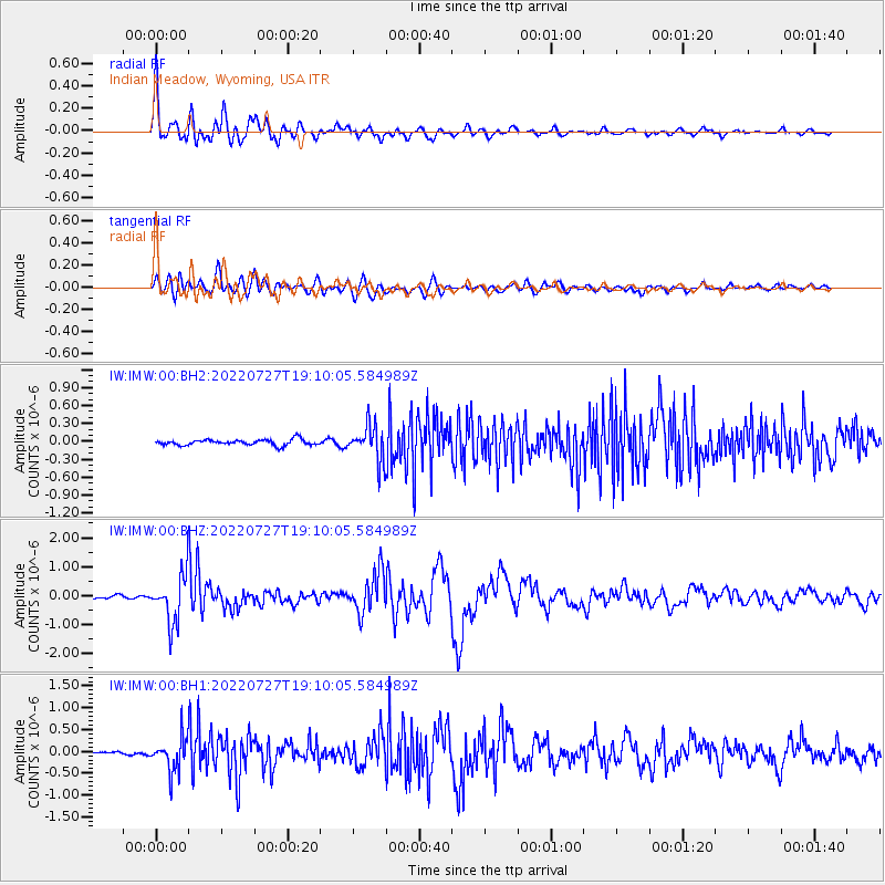
Signal To Noise
| Channel | StoN | STA | LTA |
| IW:IMW:00:BHZ:20220727T19:10:05.584989Z | 12.416833 | 8.3146114E-7 | 6.6962414E-8 |
| IW:IMW:00:BH1:20220727T19:10:05.584989Z | 9.642936 | 3.887818E-7 | 4.0317786E-8 |
| IW:IMW:00:BH2:20220727T19:10:05.584989Z | 6.269441 | 2.9995786E-7 | 4.7844434E-8 |
| Arrivals |
| Ps | 2.6 SECOND |
| PpPs | 10 SECOND |
| PsPs/PpSs | 13 SECOND |


