You are here: Home > Network List > IW - Intermountain West Stations List
> Station LOHW Long Hollow, Wyoming, USA > Earthquake Result Viewer
LOHW Long Hollow, Wyoming, USA - Earthquake Result Viewer
| Earthquake location: |
Northern Chile |
| Earthquake latitude/longitude: |
-22.2/-68.5 |
| Earthquake time(UTC): |
2022/07/27 (208) 18:58:57 GMT |
| Earthquake Depth: |
97 km |
| Earthquake Magnitude: |
6.2 Mww |
| Earthquake Catalog/Contributor: |
NEIC PDE/us |
|
| Network: |
IW Intermountain West |
| Station: |
LOHW Long Hollow, Wyoming, USA |
| Lat/Lon: |
43.61 N/110.60 W |
| Elevation: |
2121 m |
|
| Distance: |
76.0 deg |
| Az: |
329.879 deg |
| Baz: |
140.185 deg |
| Ray Param: |
0.051046986 |
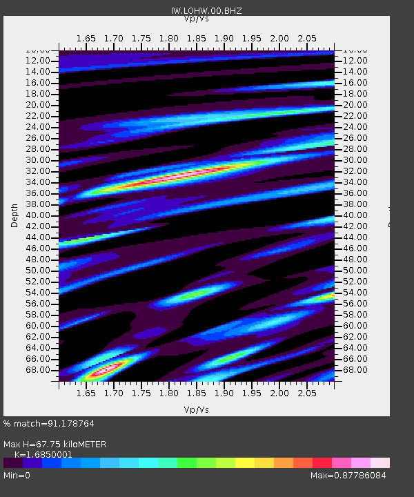
| Estimated Moho Depth: |
67.75 km |
| Estimated Crust Vp/Vs: |
1.69 |
| Assumed Crust Vp: |
6.207 km/s |
| Estimated Crust Vs: |
3.684 km/s |
| Estimated Crust Poisson's Ratio: |
0.23 |
|
| Radial Match: |
91.178764 % |
| Radial Bump: |
400 |
| Transverse Match: |
83.23039 % |
| Transverse Bump: |
400 |
| SOD ConfigId: |
28764291 |
| Insert Time: |
2022-08-10 19:23:09.195 +0000 |
| GWidth: |
2.5 |
| Max Bumps: |
400 |
| Tol: |
0.001 |
|

Signal To Noise
| Channel | StoN | STA | LTA |
| IW:LOHW:00:BHZ:20220727T19:10:03.475004Z | 16.124607 | 8.6230375E-7 | 5.3477507E-8 |
| IW:LOHW:00:BH1:20220727T19:10:03.475004Z | 6.452949 | 3.0172205E-7 | 4.6757236E-8 |
| IW:LOHW:00:BH2:20220727T19:10:03.475004Z | 4.650745 | 2.4989353E-7 | 5.3731934E-8 |
| Arrivals |
| Ps | 7.7 SECOND |
| PpPs | 28 SECOND |
| PsPs/PpSs | 36 SECOND |


