You are here: Home > Network List > IW - Intermountain West Stations List
> Station PLID Pearl Lake, Idaho, USA > Earthquake Result Viewer
PLID Pearl Lake, Idaho, USA - Earthquake Result Viewer

| Earthquake location: |
Northern Chile |
| Earthquake latitude/longitude: |
-22.2/-68.5 |
| Earthquake time(UTC): |
2022/07/27 (208) 18:58:57 GMT |
| Earthquake Depth: |
97 km |
| Earthquake Magnitude: |
6.2 Mww |
| Earthquake Catalog/Contributor: |
NEIC PDE/us |
|
| Network: |
IW Intermountain West |
| Station: |
PLID Pearl Lake, Idaho, USA |
| Lat/Lon: |
45.09 N/116.00 W |
| Elevation: |
2164 m |
|
| Distance: |
79.7 deg |
| Az: |
327.939 deg |
| Baz: |
136.016 deg |
| Ray Param: |
0.048559196 |
| Estimated Moho Depth: |
25.5 km |
| Estimated Crust Vp/Vs: |
2.10 |
| Assumed Crust Vp: |
6.571 km/s |
| Estimated Crust Vs: |
3.133 km/s |
| Estimated Crust Poisson's Ratio: |
0.35 |
|
| Radial Match: |
91.04794 % |
| Radial Bump: |
400 |
| Transverse Match: |
85.57058 % |
| Transverse Bump: |
400 |
| SOD ConfigId: |
28764291 |
| Insert Time: |
2022-08-10 19:23:14.969 +0000 |
| GWidth: |
2.5 |
| Max Bumps: |
400 |
| Tol: |
0.001 |
|
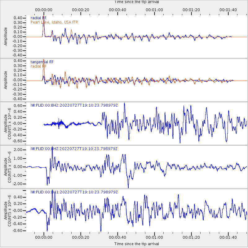
Signal To Noise
| Channel | StoN | STA | LTA |
| IW:PLID:00:BHZ:20220727T19:10:23.798979Z | 15.357344 | 1.0172441E-6 | 6.6238286E-8 |
| IW:PLID:00:BH1:20220727T19:10:23.798979Z | 5.403864 | 2.7036538E-7 | 5.003186E-8 |
| IW:PLID:00:BH2:20220727T19:10:23.798979Z | 4.495236 | 1.9707404E-7 | 4.3840647E-8 |
| Arrivals |
| Ps | 4.4 SECOND |
| PpPs | 12 SECOND |
| PsPs/PpSs | 16 SECOND |


