You are here: Home > Network List > N4 - Central and EAstern US Network Stations List
> Station O48B Farmland, IN, USA > Earthquake Result Viewer
O48B Farmland, IN, USA - Earthquake Result Viewer
| Earthquake location: |
Northern Chile |
| Earthquake latitude/longitude: |
-22.2/-68.5 |
| Earthquake time(UTC): |
2022/07/27 (208) 18:58:57 GMT |
| Earthquake Depth: |
97 km |
| Earthquake Magnitude: |
6.2 Mww |
| Earthquake Catalog/Contributor: |
NEIC PDE/us |
|
| Network: |
N4 Central and EAstern US Network |
| Station: |
O48B Farmland, IN, USA |
| Lat/Lon: |
40.26 N/85.16 W |
| Elevation: |
300 m |
|
| Distance: |
64.0 deg |
| Az: |
345.879 deg |
| Baz: |
162.815 deg |
| Ray Param: |
0.058923677 |
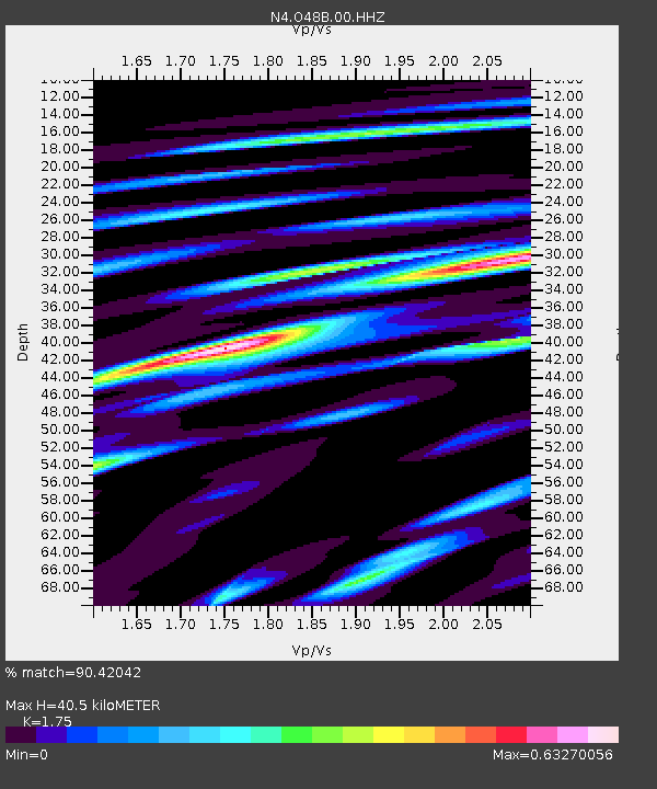
| Estimated Moho Depth: |
40.5 km |
| Estimated Crust Vp/Vs: |
1.75 |
| Assumed Crust Vp: |
6.498 km/s |
| Estimated Crust Vs: |
3.713 km/s |
| Estimated Crust Poisson's Ratio: |
0.26 |
|
| Radial Match: |
90.42042 % |
| Radial Bump: |
400 |
| Transverse Match: |
79.63711 % |
| Transverse Bump: |
400 |
| SOD ConfigId: |
28764291 |
| Insert Time: |
2022-08-10 19:26:26.132 +0000 |
| GWidth: |
2.5 |
| Max Bumps: |
400 |
| Tol: |
0.001 |
|

Signal To Noise
| Channel | StoN | STA | LTA |
| N4:O48B:00:HHZ:20220727T19:08:50.339994Z | 12.791481 | 9.667395E-7 | 7.557683E-8 |
| N4:O48B:00:HH1:20220727T19:08:50.339994Z | 5.931763 | 5.10701E-7 | 8.609599E-8 |
| N4:O48B:00:HH2:20220727T19:08:50.339994Z | 2.3271348 | 1.0909295E-7 | 4.6878654E-8 |
| Arrivals |
| Ps | 4.9 SECOND |
| PpPs | 16 SECOND |
| PsPs/PpSs | 21 SECOND |


