You are here: Home > Network List > CU - Caribbean Network (USGS) Stations List
> Station MTDJ Mount Denham, Jamaica > Earthquake Result Viewer
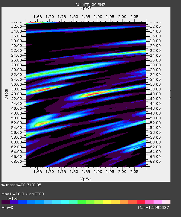
MTDJ Mount Denham, Jamaica - Earthquake Result Viewer
| Earthquake location: |
Off Coast Of Oregon |
| Earthquake latitude/longitude: |
43.6/-127.6 |
| Earthquake time(UTC): |
2018/08/22 (234) 09:31:47 GMT |
| Earthquake Depth: |
10 km |
| Earthquake Magnitude: |
6.2 Mww |
| Earthquake Catalog/Contributor: |
NEIC PDE/us |
|
| Network: |
CU Caribbean Network (USGS) |
| Station: |
MTDJ Mount Denham, Jamaica |
| Lat/Lon: |
18.23 N/77.53 W |
| Elevation: |
925 m |
|
| Distance: |
49.0 deg |
| Az: |
104.898 deg |
| Baz: |
312.429 deg |
| Ray Param: |
0.06901788 |
| Estimated Moho Depth: |
10.0 km |
| Estimated Crust Vp/Vs: |
1.60 |
| Assumed Crust Vp: |
4.662 km/s |
| Estimated Crust Vs: |
2.914 km/s |
| Estimated Crust Poisson's Ratio: |
0.18 |
|
| Radial Match: |
80.718185 % |
| Radial Bump: |
400 |
| Transverse Match: |
70.09952 % |
| Transverse Bump: |
400 |
| SOD ConfigId: |
2825771 |
| Insert Time: |
2018-09-05 09:41:31.841 +0000 |
| GWidth: |
2.5 |
| Max Bumps: |
400 |
| Tol: |
0.001 |
|

Signal To Noise
| Channel | StoN | STA | LTA |
| CU:MTDJ:00:BHZ:20180822T09:40:02.448987Z | 3.3743372 | 1.1518251E-6 | 3.4134854E-7 |
| CU:MTDJ:00:BH1:20180822T09:40:02.448987Z | 1.4288534 | 5.7635907E-7 | 4.0337173E-7 |
| CU:MTDJ:00:BH2:20180822T09:40:02.448987Z | 1.0405272 | 4.7410285E-7 | 4.5563712E-7 |
| Arrivals |
| Ps | 1.3 SECOND |
| PpPs | 5.4 SECOND |
| PsPs/PpSs | 6.7 SECOND |


