You are here: Home > Network List > O2 - Oklahoma Consolidated Temporary Seismic Networks Stations List
> Station ROSS Rosston, Oklahoma, USA > Earthquake Result Viewer
ROSS Rosston, Oklahoma, USA - Earthquake Result Viewer
| Earthquake location: |
Northern Chile |
| Earthquake latitude/longitude: |
-22.2/-68.5 |
| Earthquake time(UTC): |
2022/07/27 (208) 18:58:57 GMT |
| Earthquake Depth: |
97 km |
| Earthquake Magnitude: |
6.2 Mww |
| Earthquake Catalog/Contributor: |
NEIC PDE/us |
|
| Network: |
O2 Oklahoma Consolidated Temporary Seismic Networks |
| Station: |
ROSS Rosston, Oklahoma, USA |
| Lat/Lon: |
36.95 N/99.87 W |
| Elevation: |
607 m |
|
| Distance: |
65.8 deg |
| Az: |
332.805 deg |
| Baz: |
148.082 deg |
| Ray Param: |
0.057753578 |
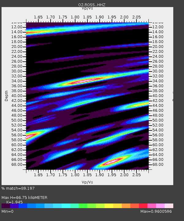
| Estimated Moho Depth: |
66.75 km |
| Estimated Crust Vp/Vs: |
1.95 |
| Assumed Crust Vp: |
6.426 km/s |
| Estimated Crust Vs: |
3.304 km/s |
| Estimated Crust Poisson's Ratio: |
0.32 |
|
| Radial Match: |
89.197 % |
| Radial Bump: |
400 |
| Transverse Match: |
75.00924 % |
| Transverse Bump: |
400 |
| SOD ConfigId: |
28764291 |
| Insert Time: |
2022-08-10 19:32:08.677 +0000 |
| GWidth: |
2.5 |
| Max Bumps: |
400 |
| Tol: |
0.001 |
|

Signal To Noise
| Channel | StoN | STA | LTA |
| O2:ROSS: :HHZ:20220727T19:09:02.024992Z | 13.57527 | 8.973521E-7 | 6.6101975E-8 |
| O2:ROSS: :HHN:20220727T19:09:02.024992Z | 5.0717816 | 3.621421E-7 | 7.140333E-8 |
| O2:ROSS: :HHE:20220727T19:09:02.024992Z | 4.3954997 | 3.8900893E-7 | 8.850164E-8 |
| Arrivals |
| Ps | 10 SECOND |
| PpPs | 29 SECOND |
| PsPs/PpSs | 40 SECOND |


