You are here: Home > Network List > NE - New England Seismic Network Stations List
> Station PQI Presque Isle, ME, USA > Earthquake Result Viewer
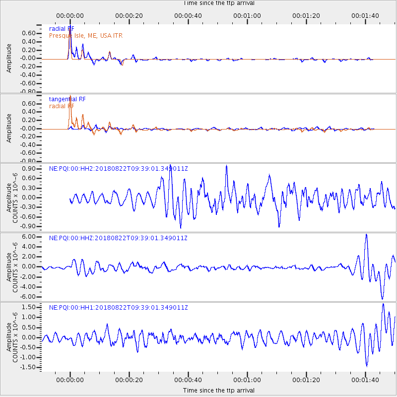
PQI Presque Isle, ME, USA - Earthquake Result Viewer
| Earthquake location: |
Off Coast Of Oregon |
| Earthquake latitude/longitude: |
43.6/-127.6 |
| Earthquake time(UTC): |
2018/08/22 (234) 09:31:47 GMT |
| Earthquake Depth: |
10 km |
| Earthquake Magnitude: |
6.2 Mww |
| Earthquake Catalog/Contributor: |
NEIC PDE/us |
|
| Network: |
NE New England Seismic Network |
| Station: |
PQI Presque Isle, ME, USA |
| Lat/Lon: |
46.67 N/68.02 W |
| Elevation: |
162 m |
|
| Distance: |
41.3 deg |
| Az: |
64.235 deg |
| Baz: |
288.305 deg |
| Ray Param: |
0.073907726 |
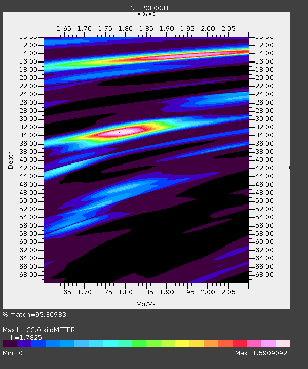
| Estimated Moho Depth: |
33.0 km |
| Estimated Crust Vp/Vs: |
1.78 |
| Assumed Crust Vp: |
6.419 km/s |
| Estimated Crust Vs: |
3.601 km/s |
| Estimated Crust Poisson's Ratio: |
0.27 |
|
| Radial Match: |
95.30983 % |
| Radial Bump: |
166 |
| Transverse Match: |
52.218037 % |
| Transverse Bump: |
400 |
| SOD ConfigId: |
2825771 |
| Insert Time: |
2018-09-05 09:44:10.030 +0000 |
| GWidth: |
2.5 |
| Max Bumps: |
400 |
| Tol: |
0.001 |
|
Signal To Noise
| Channel | StoN | STA | LTA |
| NE:PQI:00:HHZ:20180822T09:39:01.349011Z | 5.7775407 | 1.03041E-6 | 1.7834749E-7 |
| NE:PQI:00:HH1:20180822T09:39:01.349011Z | 1.508804 | 2.1672538E-7 | 1.4364052E-7 |
| NE:PQI:00:HH2:20180822T09:39:01.349011Z | 3.4932199 | 5.1444545E-7 | 1.472697E-7 |
| Arrivals |
| Ps | 4.3 SECOND |
| PpPs | 13 SECOND |
| PsPs/PpSs | 18 SECOND |


