You are here: Home > Network List > UW - Pacific Northwest Regional Seismic Network Stations List
> Station WAT2 Waterville, WA, USA > Earthquake Result Viewer
WAT2 Waterville, WA, USA - Earthquake Result Viewer
| Earthquake location: |
Northern Chile |
| Earthquake latitude/longitude: |
-22.2/-68.5 |
| Earthquake time(UTC): |
2022/07/27 (208) 18:58:57 GMT |
| Earthquake Depth: |
97 km |
| Earthquake Magnitude: |
6.2 Mww |
| Earthquake Catalog/Contributor: |
NEIC PDE/us |
|
| Network: |
UW Pacific Northwest Regional Seismic Network |
| Station: |
WAT2 Waterville, WA, USA |
| Lat/Lon: |
47.62 N/120.11 W |
| Elevation: |
875 m |
|
| Distance: |
83.5 deg |
| Az: |
327.745 deg |
| Baz: |
133.019 deg |
| Ray Param: |
0.045916494 |
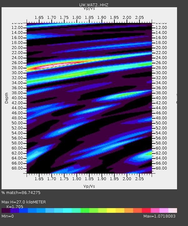
| Estimated Moho Depth: |
27.0 km |
| Estimated Crust Vp/Vs: |
1.71 |
| Assumed Crust Vp: |
6.597 km/s |
| Estimated Crust Vs: |
3.87 km/s |
| Estimated Crust Poisson's Ratio: |
0.24 |
|
| Radial Match: |
86.74275 % |
| Radial Bump: |
400 |
| Transverse Match: |
73.98492 % |
| Transverse Bump: |
400 |
| SOD ConfigId: |
28764291 |
| Insert Time: |
2022-08-10 19:46:01.676 +0000 |
| GWidth: |
2.5 |
| Max Bumps: |
400 |
| Tol: |
0.001 |
|

Signal To Noise
| Channel | StoN | STA | LTA |
| UW:WAT2: :HHZ:20220727T19:10:43.730009Z | 13.631964 | 1.0646439E-6 | 7.8099085E-8 |
| UW:WAT2: :HHN:20220727T19:10:43.730009Z | 3.766755 | 2.6156536E-7 | 6.94405E-8 |
| UW:WAT2: :HHE:20220727T19:10:43.730009Z | 5.186347 | 3.3142288E-7 | 6.390295E-8 |
| Arrivals |
| Ps | 3.0 SECOND |
| PpPs | 11 SECOND |
| PsPs/PpSs | 14 SECOND |


