You are here: Home > Network List > AE - Arizona Broadband Seismic Network Stations List
> Station U15A North Rim, AZ, USA > Earthquake Result Viewer
U15A North Rim, AZ, USA - Earthquake Result Viewer
| Earthquake location: |
Near Coast Of Northern Chile |
| Earthquake latitude/longitude: |
-21.9/-70.3 |
| Earthquake time(UTC): |
2022/07/28 (209) 04:15:05 GMT |
| Earthquake Depth: |
54 km |
| Earthquake Magnitude: |
6.1 mww |
| Earthquake Catalog/Contributor: |
NEIC PDE/us |
|
| Network: |
AE Arizona Broadband Seismic Network |
| Station: |
U15A North Rim, AZ, USA |
| Lat/Lon: |
36.43 N/112.29 W |
| Elevation: |
2489 m |
|
| Distance: |
70.3 deg |
| Az: |
325.06 deg |
| Baz: |
138.751 deg |
| Ray Param: |
0.054988887 |
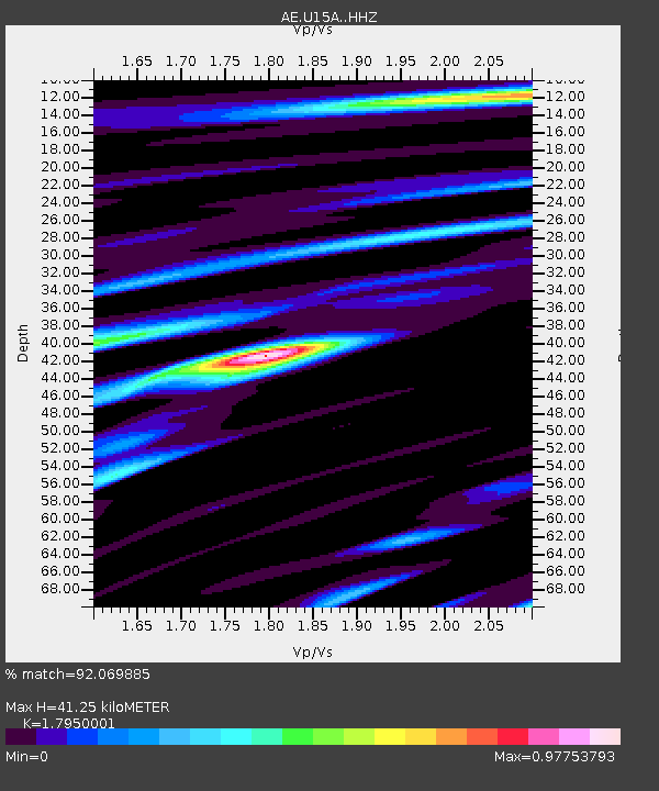
| Estimated Moho Depth: |
41.25 km |
| Estimated Crust Vp/Vs: |
1.80 |
| Assumed Crust Vp: |
6.194 km/s |
| Estimated Crust Vs: |
3.451 km/s |
| Estimated Crust Poisson's Ratio: |
0.27 |
|
| Radial Match: |
92.069885 % |
| Radial Bump: |
400 |
| Transverse Match: |
90.15603 % |
| Transverse Bump: |
400 |
| SOD ConfigId: |
28764291 |
| Insert Time: |
2022-08-11 04:18:33.832 +0000 |
| GWidth: |
2.5 |
| Max Bumps: |
400 |
| Tol: |
0.001 |
|

Signal To Noise
| Channel | StoN | STA | LTA |
| AE:U15A: :HHZ:20220728T04:25:41.949998Z | 83.56368 | 3.2586788E-6 | 3.8996355E-8 |
| AE:U15A: :HHN:20220728T04:25:41.949998Z | 16.392515 | 8.3246937E-7 | 5.0783502E-8 |
| AE:U15A: :HHE:20220728T04:25:41.949998Z | 16.722511 | 7.5626025E-7 | 4.5224084E-8 |
| Arrivals |
| Ps | 5.5 SECOND |
| PpPs | 18 SECOND |
| PsPs/PpSs | 23 SECOND |


