You are here: Home > Network List > AZ - ANZA Regional Network Stations List
> Station RRSP RRSP, CA, USA > Earthquake Result Viewer
RRSP RRSP, CA, USA - Earthquake Result Viewer
| Earthquake location: |
Near Coast Of Northern Chile |
| Earthquake latitude/longitude: |
-21.9/-70.3 |
| Earthquake time(UTC): |
2022/07/28 (209) 04:15:05 GMT |
| Earthquake Depth: |
54 km |
| Earthquake Magnitude: |
6.1 mww |
| Earthquake Catalog/Contributor: |
NEIC PDE/us |
|
| Network: |
AZ ANZA Regional Network |
| Station: |
RRSP RRSP, CA, USA |
| Lat/Lon: |
33.65 N/116.74 W |
| Elevation: |
1610 m |
|
| Distance: |
70.8 deg |
| Az: |
320.229 deg |
| Baz: |
134.596 deg |
| Ray Param: |
0.054654438 |
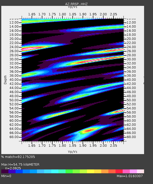
| Estimated Moho Depth: |
54.75 km |
| Estimated Crust Vp/Vs: |
2.09 |
| Assumed Crust Vp: |
6.264 km/s |
| Estimated Crust Vs: |
2.993 km/s |
| Estimated Crust Poisson's Ratio: |
0.35 |
|
| Radial Match: |
92.175285 % |
| Radial Bump: |
400 |
| Transverse Match: |
89.83015 % |
| Transverse Bump: |
400 |
| SOD ConfigId: |
28764291 |
| Insert Time: |
2022-08-11 04:19:56.382 +0000 |
| GWidth: |
2.5 |
| Max Bumps: |
400 |
| Tol: |
0.001 |
|

Signal To Noise
| Channel | StoN | STA | LTA |
| AZ:RRSP: :HHZ:20220728T04:25:44.929001Z | 48.367283 | 3.3627857E-6 | 6.9526045E-8 |
| AZ:RRSP: :HHN:20220728T04:25:44.929001Z | 6.9510903 | 7.517871E-7 | 1.0815384E-7 |
| AZ:RRSP: :HHE:20220728T04:25:44.929001Z | 11.61649 | 9.764062E-7 | 8.405347E-8 |
| Arrivals |
| Ps | 9.8 SECOND |
| PpPs | 26 SECOND |
| PsPs/PpSs | 36 SECOND |


