You are here: Home > Network List > CI - Caltech Regional Seismic Network Stations List
> Station SMM Simmler, CA, USA > Earthquake Result Viewer
SMM Simmler, CA, USA - Earthquake Result Viewer
| Earthquake location: |
Near Coast Of Northern Chile |
| Earthquake latitude/longitude: |
-21.9/-70.3 |
| Earthquake time(UTC): |
2022/07/28 (209) 04:15:05 GMT |
| Earthquake Depth: |
54 km |
| Earthquake Magnitude: |
6.1 mww |
| Earthquake Catalog/Contributor: |
NEIC PDE/us |
|
| Network: |
CI Caltech Regional Seismic Network |
| Station: |
SMM Simmler, CA, USA |
| Lat/Lon: |
35.31 N/120.00 W |
| Elevation: |
599 m |
|
| Distance: |
73.9 deg |
| Az: |
319.544 deg |
| Baz: |
132.552 deg |
| Ray Param: |
0.052622758 |
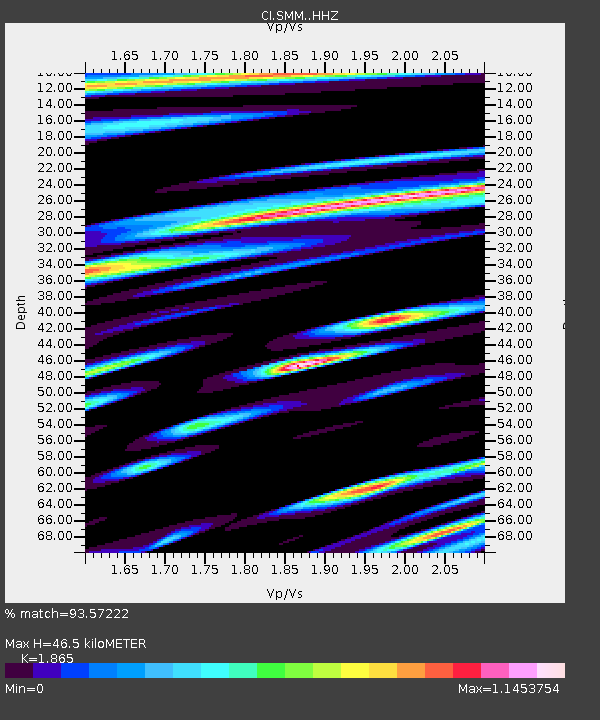
| Estimated Moho Depth: |
46.5 km |
| Estimated Crust Vp/Vs: |
1.87 |
| Assumed Crust Vp: |
6.1 km/s |
| Estimated Crust Vs: |
3.271 km/s |
| Estimated Crust Poisson's Ratio: |
0.30 |
|
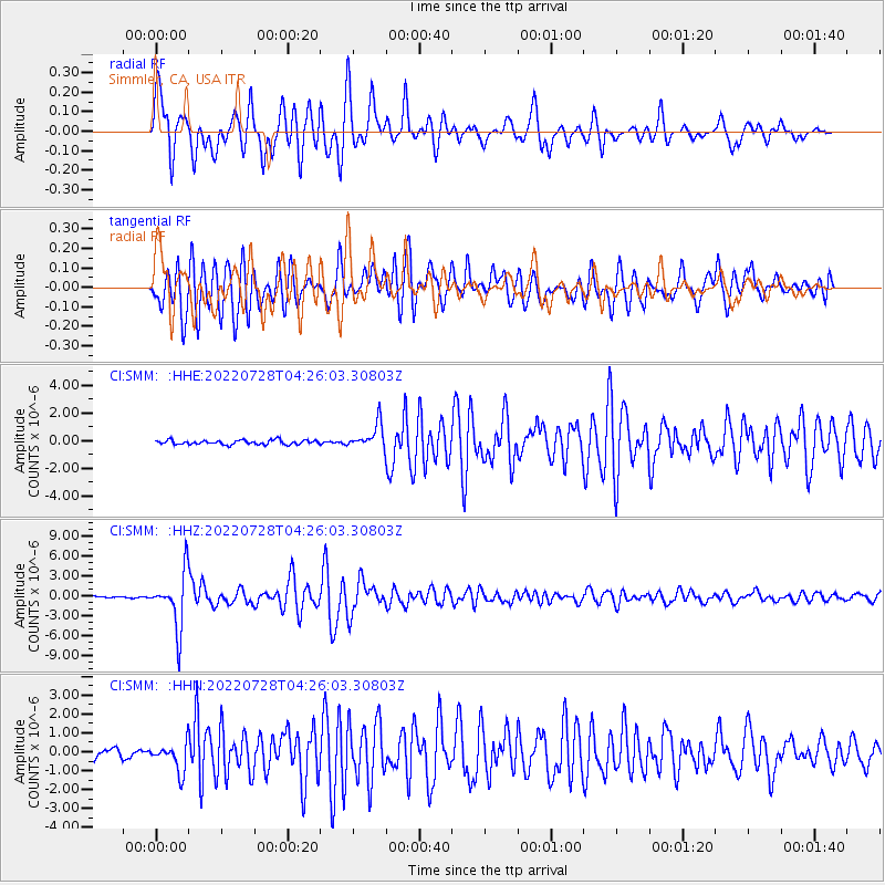
| Radial Match: |
93.57222 % |
| Radial Bump: |
400 |
| Transverse Match: |
87.33258 % |
| Transverse Bump: |
400 |
| SOD ConfigId: |
28764291 |
| Insert Time: |
2022-08-11 04:31:32.620 +0000 |
| GWidth: |
2.5 |
| Max Bumps: |
400 |
| Tol: |
0.001 |
|
Signal To Noise
| Channel | StoN | STA | LTA |
| CI:SMM: :HHZ:20220728T04:26:03.30803Z | 22.74281 | 4.131945E-6 | 1.8168139E-7 |
| CI:SMM: :HHN:20220728T04:26:03.30803Z | 3.1580598 | 7.4902323E-7 | 2.371783E-7 |
| CI:SMM: :HHE:20220728T04:26:03.30803Z | 5.6700454 | 9.0387374E-7 | 1.5941208E-7 |
| Arrivals |
| Ps | 6.8 SECOND |
| PpPs | 21 SECOND |
| PsPs/PpSs | 28 SECOND |


