You are here: Home > Network List > CN - Canadian National Seismograph Network Stations List
> Station FCC Fort Churchill, MB, CA > Earthquake Result Viewer
FCC Fort Churchill, MB, CA - Earthquake Result Viewer
| Earthquake location: |
Near Coast Of Northern Chile |
| Earthquake latitude/longitude: |
-21.9/-70.3 |
| Earthquake time(UTC): |
2022/07/28 (209) 04:15:05 GMT |
| Earthquake Depth: |
54 km |
| Earthquake Magnitude: |
6.1 mww |
| Earthquake Catalog/Contributor: |
NEIC PDE/us |
|
| Network: |
CN Canadian National Seismograph Network |
| Station: |
FCC Fort Churchill, MB, CA |
| Lat/Lon: |
58.76 N/94.09 W |
| Elevation: |
39 m |
|
| Distance: |
82.8 deg |
| Az: |
347.787 deg |
| Baz: |
157.859 deg |
| Ray Param: |
0.04656884 |
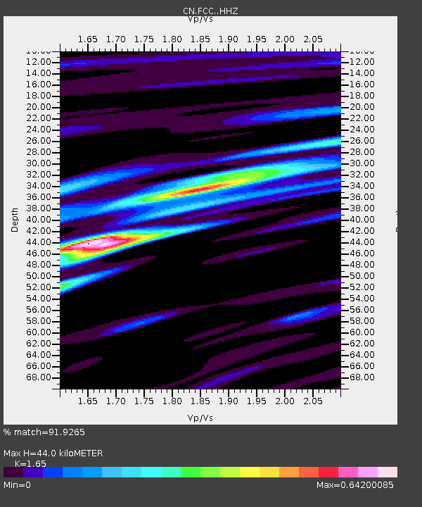
| Estimated Moho Depth: |
44.0 km |
| Estimated Crust Vp/Vs: |
1.65 |
| Assumed Crust Vp: |
6.455 km/s |
| Estimated Crust Vs: |
3.912 km/s |
| Estimated Crust Poisson's Ratio: |
0.21 |
|
| Radial Match: |
91.9265 % |
| Radial Bump: |
252 |
| Transverse Match: |
86.55021 % |
| Transverse Bump: |
400 |
| SOD ConfigId: |
28764291 |
| Insert Time: |
2022-08-11 04:34:07.272 +0000 |
| GWidth: |
2.5 |
| Max Bumps: |
400 |
| Tol: |
0.001 |
|

Signal To Noise
| Channel | StoN | STA | LTA |
| CN:FCC: :HHZ:20220728T04:26:52.230027Z | 30.423891 | 1.9910728E-6 | 6.544439E-8 |
| CN:FCC: :HHN:20220728T04:26:52.230027Z | 17.006063 | 7.412178E-7 | 4.3585505E-8 |
| CN:FCC: :HHE:20220728T04:26:52.230027Z | 2.4724414 | 1.3795798E-7 | 5.5798278E-8 |
| Arrivals |
| Ps | 4.6 SECOND |
| PpPs | 18 SECOND |
| PsPs/PpSs | 22 SECOND |


