You are here: Home > Network List > GM - US Geological Survey Networks Stations List
> Station NMP34 New Mexico Permian - Site# W3S4 > Earthquake Result Viewer
NMP34 New Mexico Permian - Site# W3S4 - Earthquake Result Viewer
| Earthquake location: |
Near Coast Of Northern Chile |
| Earthquake latitude/longitude: |
-21.9/-70.3 |
| Earthquake time(UTC): |
2022/07/28 (209) 04:15:05 GMT |
| Earthquake Depth: |
54 km |
| Earthquake Magnitude: |
6.1 mww |
| Earthquake Catalog/Contributor: |
NEIC PDE/us |
|
| Network: |
GM US Geological Survey Networks |
| Station: |
NMP34 New Mexico Permian - Site# W3S4 |
| Lat/Lon: |
32.26 N/103.69 W |
| Elevation: |
1122 m |
|
| Distance: |
62.6 deg |
| Az: |
328.367 deg |
| Baz: |
144.916 deg |
| Ray Param: |
0.059977878 |
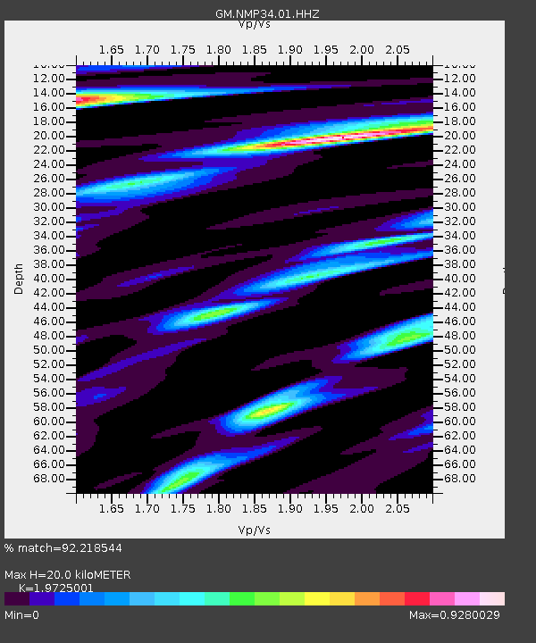
| Estimated Moho Depth: |
20.0 km |
| Estimated Crust Vp/Vs: |
1.97 |
| Assumed Crust Vp: |
6.129 km/s |
| Estimated Crust Vs: |
3.107 km/s |
| Estimated Crust Poisson's Ratio: |
0.33 |
|
| Radial Match: |
92.218544 % |
| Radial Bump: |
348 |
| Transverse Match: |
85.68552 % |
| Transverse Bump: |
400 |
| SOD ConfigId: |
28764291 |
| Insert Time: |
2022-08-11 04:41:47.564 +0000 |
| GWidth: |
2.5 |
| Max Bumps: |
400 |
| Tol: |
0.001 |
|

Signal To Noise
| Channel | StoN | STA | LTA |
| GM:NMP34:01:HHZ:20220728T04:24:53.170029Z | 57.970764 | 5.0244157E-6 | 8.667155E-8 |
| GM:NMP34:01:HHN:20220728T04:24:53.170029Z | 13.2277155 | 1.3568136E-6 | 1.02573544E-7 |
| GM:NMP34:01:HHE:20220728T04:24:53.170029Z | 12.895953 | 1.1959625E-6 | 9.2739356E-8 |
| Arrivals |
| Ps | 3.3 SECOND |
| PpPs | 9.4 SECOND |
| PsPs/PpSs | 13 SECOND |


