You are here: Home > Network List > GM - US Geological Survey Networks Stations List
> Station NMP51 New Mexico Permian - Site# W5S1 > Earthquake Result Viewer
NMP51 New Mexico Permian - Site# W5S1 - Earthquake Result Viewer
| Earthquake location: |
Near Coast Of Northern Chile |
| Earthquake latitude/longitude: |
-21.9/-70.3 |
| Earthquake time(UTC): |
2022/07/28 (209) 04:15:05 GMT |
| Earthquake Depth: |
54 km |
| Earthquake Magnitude: |
6.1 mww |
| Earthquake Catalog/Contributor: |
NEIC PDE/us |
|
| Network: |
GM US Geological Survey Networks |
| Station: |
NMP51 New Mexico Permian - Site# W5S1 |
| Lat/Lon: |
32.00 N/103.42 W |
| Elevation: |
975 m |
|
| Distance: |
62.3 deg |
| Az: |
328.41 deg |
| Baz: |
145.077 deg |
| Ray Param: |
0.060205128 |
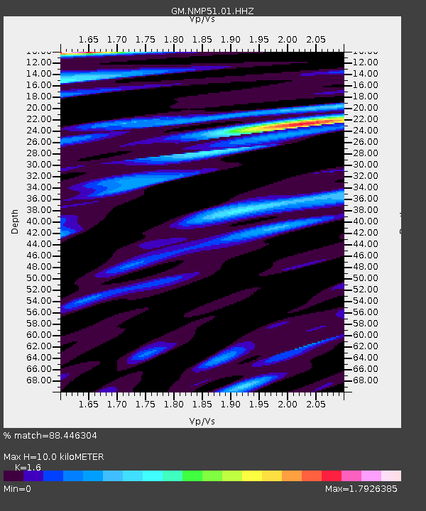
| Estimated Moho Depth: |
10.0 km |
| Estimated Crust Vp/Vs: |
1.60 |
| Assumed Crust Vp: |
6.129 km/s |
| Estimated Crust Vs: |
3.831 km/s |
| Estimated Crust Poisson's Ratio: |
0.18 |
|
| Radial Match: |
88.446304 % |
| Radial Bump: |
400 |
| Transverse Match: |
87.55013 % |
| Transverse Bump: |
400 |
| SOD ConfigId: |
28764291 |
| Insert Time: |
2022-08-11 04:41:58.322 +0000 |
| GWidth: |
2.5 |
| Max Bumps: |
400 |
| Tol: |
0.001 |
|

Signal To Noise
| Channel | StoN | STA | LTA |
| GM:NMP51:01:HHZ:20220728T04:24:50.895005Z | 43.52132 | 3.7718355E-6 | 8.666638E-8 |
| GM:NMP51:01:HHN:20220728T04:24:50.895005Z | 17.015202 | 1.1405347E-6 | 6.703034E-8 |
| GM:NMP51:01:HHE:20220728T04:24:50.895005Z | 14.6839285 | 1.1805682E-6 | 8.0398664E-8 |
| Arrivals |
| Ps | 1.0 SECOND |
| PpPs | 4.1 SECOND |
| PsPs/PpSs | 5.1 SECOND |


