You are here: Home > Network List > N4 - Central and EAstern US Network Stations List
> Station I49A Point Hope, MI, USA > Earthquake Result Viewer
I49A Point Hope, MI, USA - Earthquake Result Viewer
| Earthquake location: |
Near Coast Of Northern Chile |
| Earthquake latitude/longitude: |
-21.9/-70.3 |
| Earthquake time(UTC): |
2022/07/28 (209) 04:15:05 GMT |
| Earthquake Depth: |
54 km |
| Earthquake Magnitude: |
6.1 mww |
| Earthquake Catalog/Contributor: |
NEIC PDE/us |
|
| Network: |
N4 Central and EAstern US Network |
| Station: |
I49A Point Hope, MI, USA |
| Lat/Lon: |
43.94 N/82.82 W |
| Elevation: |
217 m |
|
| Distance: |
66.5 deg |
| Az: |
350.199 deg |
| Baz: |
167.362 deg |
| Ray Param: |
0.057432853 |
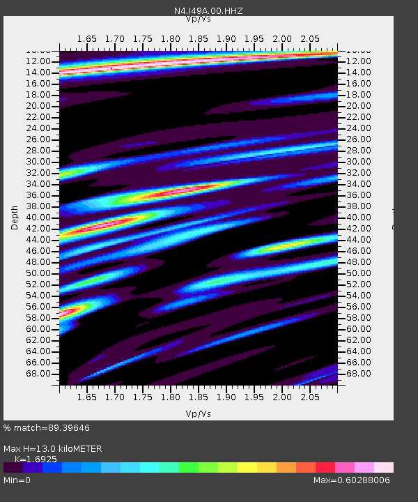
| Estimated Moho Depth: |
13.0 km |
| Estimated Crust Vp/Vs: |
1.69 |
| Assumed Crust Vp: |
6.483 km/s |
| Estimated Crust Vs: |
3.83 km/s |
| Estimated Crust Poisson's Ratio: |
0.23 |
|
| Radial Match: |
89.39646 % |
| Radial Bump: |
357 |
| Transverse Match: |
72.84648 % |
| Transverse Bump: |
400 |
| SOD ConfigId: |
28764291 |
| Insert Time: |
2022-08-11 04:48:54.168 +0000 |
| GWidth: |
2.5 |
| Max Bumps: |
400 |
| Tol: |
0.001 |
|

Signal To Noise
| Channel | StoN | STA | LTA |
| N4:I49A:00:HHZ:20220728T04:25:18.648972Z | 15.768578 | 2.163831E-6 | 1.3722423E-7 |
| N4:I49A:00:HH1:20220728T04:25:18.648972Z | 9.767845 | 8.783064E-7 | 8.991814E-8 |
| N4:I49A:00:HH2:20220728T04:25:18.648972Z | 1.7354192 | 2.143786E-7 | 1.2353131E-7 |
| Arrivals |
| Ps | 1.4 SECOND |
| PpPs | 5.2 SECOND |
| PsPs/PpSs | 6.6 SECOND |


