You are here: Home > Network List > N4 - Central and EAstern US Network Stations List
> Station MSTX Muleshoe, TX, USA > Earthquake Result Viewer
MSTX Muleshoe, TX, USA - Earthquake Result Viewer
| Earthquake location: |
Near Coast Of Northern Chile |
| Earthquake latitude/longitude: |
-21.9/-70.3 |
| Earthquake time(UTC): |
2022/07/28 (209) 04:15:05 GMT |
| Earthquake Depth: |
54 km |
| Earthquake Magnitude: |
6.1 mww |
| Earthquake Catalog/Contributor: |
NEIC PDE/us |
|
| Network: |
N4 Central and EAstern US Network |
| Station: |
MSTX Muleshoe, TX, USA |
| Lat/Lon: |
33.97 N/102.77 W |
| Elevation: |
1167 m |
|
| Distance: |
63.6 deg |
| Az: |
330.158 deg |
| Baz: |
146.224 deg |
| Ray Param: |
0.05935862 |
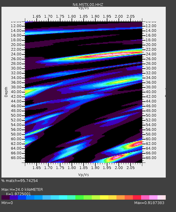
| Estimated Moho Depth: |
24.0 km |
| Estimated Crust Vp/Vs: |
1.97 |
| Assumed Crust Vp: |
6.129 km/s |
| Estimated Crust Vs: |
3.107 km/s |
| Estimated Crust Poisson's Ratio: |
0.33 |
|
| Radial Match: |
95.74254 % |
| Radial Bump: |
324 |
| Transverse Match: |
82.77353 % |
| Transverse Bump: |
332 |
| SOD ConfigId: |
28764291 |
| Insert Time: |
2022-08-11 04:49:23.396 +0000 |
| GWidth: |
2.5 |
| Max Bumps: |
400 |
| Tol: |
0.001 |
|

Signal To Noise
| Channel | StoN | STA | LTA |
| N4:MSTX:00:HHZ:20220728T04:24:59.569993Z | 52.954117 | 3.7291647E-6 | 7.0422566E-8 |
| N4:MSTX:00:HH1:20220728T04:24:59.569993Z | 24.772741 | 1.597858E-6 | 6.4500654E-8 |
| N4:MSTX:00:HH2:20220728T04:24:59.569993Z | 22.09981 | 1.0609735E-6 | 4.8008268E-8 |
| Arrivals |
| Ps | 3.9 SECOND |
| PpPs | 11 SECOND |
| PsPs/PpSs | 15 SECOND |


