You are here: Home > Network List > GS - US Geological Survey Networks Stations List
> Station OK029 Liberty Lake, Oklahoma, USA > Earthquake Result Viewer
OK029 Liberty Lake, Oklahoma, USA - Earthquake Result Viewer
| Earthquake location: |
Near Coast Of Venezuela |
| Earthquake latitude/longitude: |
10.6/-62.9 |
| Earthquake time(UTC): |
2018/08/22 (234) 13:27:47 GMT |
| Earthquake Depth: |
98 km |
| Earthquake Magnitude: |
5.8 Mww |
| Earthquake Catalog/Contributor: |
NEIC PDE/us |
|
| Network: |
GS US Geological Survey Networks |
| Station: |
OK029 Liberty Lake, Oklahoma, USA |
| Lat/Lon: |
35.80 N/97.45 W |
| Elevation: |
333 m |
|
| Distance: |
40.1 deg |
| Az: |
314.337 deg |
| Baz: |
120.115 deg |
| Ray Param: |
0.07426805 |
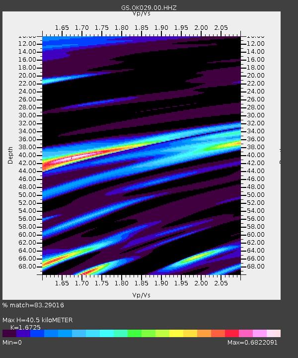
| Estimated Moho Depth: |
40.5 km |
| Estimated Crust Vp/Vs: |
1.67 |
| Assumed Crust Vp: |
6.426 km/s |
| Estimated Crust Vs: |
3.842 km/s |
| Estimated Crust Poisson's Ratio: |
0.22 |
|
| Radial Match: |
83.29016 % |
| Radial Bump: |
282 |
| Transverse Match: |
56.61775 % |
| Transverse Bump: |
296 |
| SOD ConfigId: |
2825771 |
| Insert Time: |
2018-09-05 13:41:54.669 +0000 |
| GWidth: |
2.5 |
| Max Bumps: |
400 |
| Tol: |
0.001 |
|

Signal To Noise
| Channel | StoN | STA | LTA |
| GS:OK029:00:HHZ:20180822T13:34:43.349989Z | 6.4194427 | 8.191358E-7 | 1.2760232E-7 |
| GS:OK029:00:HH1:20180822T13:34:43.349989Z | 1.9835967 | 3.0424647E-7 | 1.5338121E-7 |
| GS:OK029:00:HH2:20180822T13:34:43.349989Z | 2.504723 | 3.5822174E-7 | 1.4301851E-7 |
| Arrivals |
| Ps | 4.6 SECOND |
| PpPs | 16 SECOND |
| PsPs/PpSs | 20 SECOND |


