You are here: Home > Network List > NM - Cooperative New Madrid Seismic Network Stations List
> Station LPAR Lepanto,AR > Earthquake Result Viewer
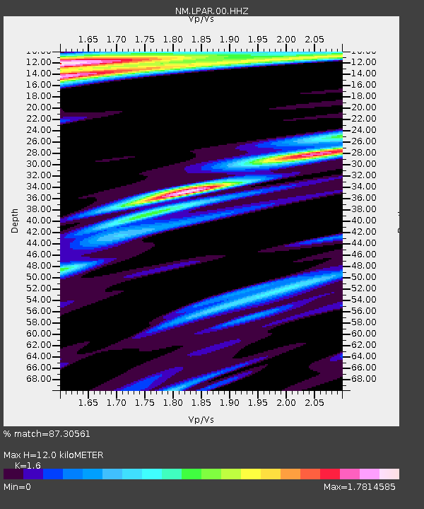
LPAR Lepanto,AR - Earthquake Result Viewer
| Earthquake location: |
Near Coast Of Northern Chile |
| Earthquake latitude/longitude: |
-21.9/-70.3 |
| Earthquake time(UTC): |
2022/07/28 (209) 04:15:05 GMT |
| Earthquake Depth: |
54 km |
| Earthquake Magnitude: |
6.1 mww |
| Earthquake Catalog/Contributor: |
NEIC PDE/us |
|
| Network: |
NM Cooperative New Madrid Seismic Network |
| Station: |
LPAR Lepanto,AR |
| Lat/Lon: |
35.60 N/90.30 W |
| Elevation: |
67 m |
|
| Distance: |
60.3 deg |
| Az: |
341.316 deg |
| Baz: |
158.593 deg |
| Ray Param: |
0.061529614 |
| Estimated Moho Depth: |
12.0 km |
| Estimated Crust Vp/Vs: |
1.60 |
| Assumed Crust Vp: |
6.273 km/s |
| Estimated Crust Vs: |
3.921 km/s |
| Estimated Crust Poisson's Ratio: |
0.18 |
|
| Radial Match: |
87.30561 % |
| Radial Bump: |
324 |
| Transverse Match: |
70.35789 % |
| Transverse Bump: |
346 |
| SOD ConfigId: |
28764291 |
| Insert Time: |
2022-08-11 04:51:41.048 +0000 |
| GWidth: |
2.5 |
| Max Bumps: |
400 |
| Tol: |
0.001 |
|

Signal To Noise
| Channel | StoN | STA | LTA |
| NM:LPAR:00:HHZ:20220728T04:24:37.290024Z | 33.612587 | 4.3137993E-6 | 1.2833881E-7 |
| NM:LPAR:00:HHN:20220728T04:24:37.290024Z | 8.287622 | 2.18682E-6 | 2.6386576E-7 |
| NM:LPAR:00:HHE:20220728T04:24:37.290024Z | 3.8507817 | 9.812541E-7 | 2.5481944E-7 |
| Arrivals |
| Ps | 1.2 SECOND |
| PpPs | 4.7 SECOND |
| PsPs/PpSs | 5.9 SECOND |


