You are here: Home > Network List > TX - Texas Seismological Network Stations List
> Station PB12 Southwest of Toyah > Earthquake Result Viewer
PB12 Southwest of Toyah - Earthquake Result Viewer
| Earthquake location: |
Near Coast Of Northern Chile |
| Earthquake latitude/longitude: |
-21.9/-70.3 |
| Earthquake time(UTC): |
2022/07/28 (209) 04:15:05 GMT |
| Earthquake Depth: |
54 km |
| Earthquake Magnitude: |
6.1 mww |
| Earthquake Catalog/Contributor: |
NEIC PDE/us |
|
| Network: |
TX Texas Seismological Network |
| Station: |
PB12 Southwest of Toyah |
| Lat/Lon: |
31.20 N/104.05 W |
| Elevation: |
962 m |
|
| Distance: |
61.9 deg |
| Az: |
327.391 deg |
| Baz: |
144.274 deg |
| Ray Param: |
0.06043745 |
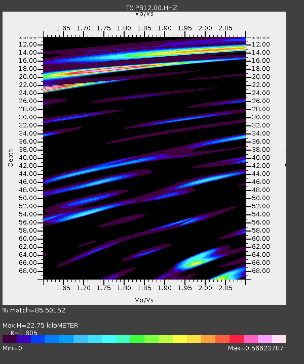
| Estimated Moho Depth: |
22.75 km |
| Estimated Crust Vp/Vs: |
1.61 |
| Assumed Crust Vp: |
6.361 km/s |
| Estimated Crust Vs: |
3.963 km/s |
| Estimated Crust Poisson's Ratio: |
0.18 |
|
| Radial Match: |
85.50152 % |
| Radial Bump: |
400 |
| Transverse Match: |
74.594025 % |
| Transverse Bump: |
400 |
| SOD ConfigId: |
28764291 |
| Insert Time: |
2022-08-11 05:07:37.405 +0000 |
| GWidth: |
2.5 |
| Max Bumps: |
400 |
| Tol: |
0.001 |
|

Signal To Noise
| Channel | StoN | STA | LTA |
| TX:PB12:00:HHZ:20220728T04:24:48.355027Z | 63.893497 | 3.7999467E-5 | 5.947313E-7 |
| TX:PB12:00:HHN:20220728T04:24:48.355027Z | 20.056707 | 1.5717029E-5 | 7.8362956E-7 |
| TX:PB12:00:HHE:20220728T04:24:48.355027Z | 5.845896 | 1.1518832E-5 | 1.9704135E-6 |
| Arrivals |
| Ps | 2.3 SECOND |
| PpPs | 8.9 SECOND |
| PsPs/PpSs | 11 SECOND |


