You are here: Home > Network List > TX - Texas Seismological Network Stations List
> Station PB19 West of Imperial > Earthquake Result Viewer
PB19 West of Imperial - Earthquake Result Viewer
| Earthquake location: |
Near Coast Of Northern Chile |
| Earthquake latitude/longitude: |
-21.9/-70.3 |
| Earthquake time(UTC): |
2022/07/28 (209) 04:15:05 GMT |
| Earthquake Depth: |
54 km |
| Earthquake Magnitude: |
6.1 mww |
| Earthquake Catalog/Contributor: |
NEIC PDE/us |
|
| Network: |
TX Texas Seismological Network |
| Station: |
PB19 West of Imperial |
| Lat/Lon: |
31.30 N/103.10 W |
| Elevation: |
782 m |
|
| Distance: |
61.6 deg |
| Az: |
328.212 deg |
| Baz: |
145.152 deg |
| Ray Param: |
0.06068387 |
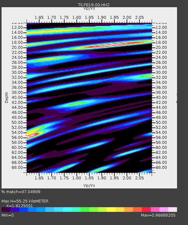
| Estimated Moho Depth: |
55.25 km |
| Estimated Crust Vp/Vs: |
1.61 |
| Assumed Crust Vp: |
6.121 km/s |
| Estimated Crust Vs: |
3.796 km/s |
| Estimated Crust Poisson's Ratio: |
0.19 |
|
| Radial Match: |
87.04989 % |
| Radial Bump: |
400 |
| Transverse Match: |
66.62223 % |
| Transverse Bump: |
400 |
| SOD ConfigId: |
28764291 |
| Insert Time: |
2022-08-11 05:07:46.537 +0000 |
| GWidth: |
2.5 |
| Max Bumps: |
400 |
| Tol: |
0.001 |
|

Signal To Noise
| Channel | StoN | STA | LTA |
| TX:PB19:00:HHZ:20220728T04:24:45.999985Z | 33.895477 | 4.5375775E-5 | 1.338697E-6 |
| TX:PB19:00:HHN:20220728T04:24:45.999985Z | 3.0405633 | 1.0444111E-5 | 3.4349262E-6 |
| TX:PB19:00:HHE:20220728T04:24:45.999985Z | 5.4460936 | 1.1374588E-5 | 2.0885775E-6 |
| Arrivals |
| Ps | 5.8 SECOND |
| PpPs | 23 SECOND |
| PsPs/PpSs | 28 SECOND |


