You are here: Home > Network List > US - United States National Seismic Network Stations List
> Station CBKS Cedar Bluff, Kansas, USA > Earthquake Result Viewer
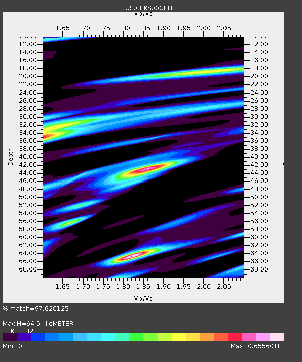
CBKS Cedar Bluff, Kansas, USA - Earthquake Result Viewer
| Earthquake location: |
Near Coast Of Northern Chile |
| Earthquake latitude/longitude: |
-21.9/-70.3 |
| Earthquake time(UTC): |
2022/07/28 (209) 04:15:05 GMT |
| Earthquake Depth: |
54 km |
| Earthquake Magnitude: |
6.1 mww |
| Earthquake Catalog/Contributor: |
NEIC PDE/us |
|
| Network: |
US United States National Seismic Network |
| Station: |
CBKS Cedar Bluff, Kansas, USA |
| Lat/Lon: |
38.81 N/99.74 W |
| Elevation: |
677 m |
|
| Distance: |
66.4 deg |
| Az: |
335.264 deg |
| Baz: |
150.179 deg |
| Ray Param: |
0.05751852 |
| Estimated Moho Depth: |
64.5 km |
| Estimated Crust Vp/Vs: |
1.82 |
| Assumed Crust Vp: |
6.483 km/s |
| Estimated Crust Vs: |
3.562 km/s |
| Estimated Crust Poisson's Ratio: |
0.28 |
|
| Radial Match: |
97.620125 % |
| Radial Bump: |
279 |
| Transverse Match: |
91.81582 % |
| Transverse Bump: |
400 |
| SOD ConfigId: |
28764291 |
| Insert Time: |
2022-08-11 05:11:29.581 +0000 |
| GWidth: |
2.5 |
| Max Bumps: |
400 |
| Tol: |
0.001 |
|

Signal To Noise
| Channel | StoN | STA | LTA |
| US:CBKS:00:BHZ:20220728T04:25:17.824021Z | 56.847332 | 3.8790467E-6 | 6.823621E-8 |
| US:CBKS:00:BH1:20220728T04:25:17.824021Z | 25.285028 | 2.3215443E-6 | 9.181498E-8 |
| US:CBKS:00:BH2:20220728T04:25:17.824021Z | 20.724356 | 1.30296E-6 | 6.287095E-8 |
| Arrivals |
| Ps | 8.5 SECOND |
| PpPs | 27 SECOND |
| PsPs/PpSs | 35 SECOND |


