You are here: Home > Network List > US - United States National Seismic Network Stations List
> Station ERPA Erie, Pennsylvania, USA > Earthquake Result Viewer
ERPA Erie, Pennsylvania, USA - Earthquake Result Viewer
| Earthquake location: |
Near Coast Of Northern Chile |
| Earthquake latitude/longitude: |
-21.9/-70.3 |
| Earthquake time(UTC): |
2022/07/28 (209) 04:15:05 GMT |
| Earthquake Depth: |
54 km |
| Earthquake Magnitude: |
6.1 mww |
| Earthquake Catalog/Contributor: |
NEIC PDE/us |
|
| Network: |
US United States National Seismic Network |
| Station: |
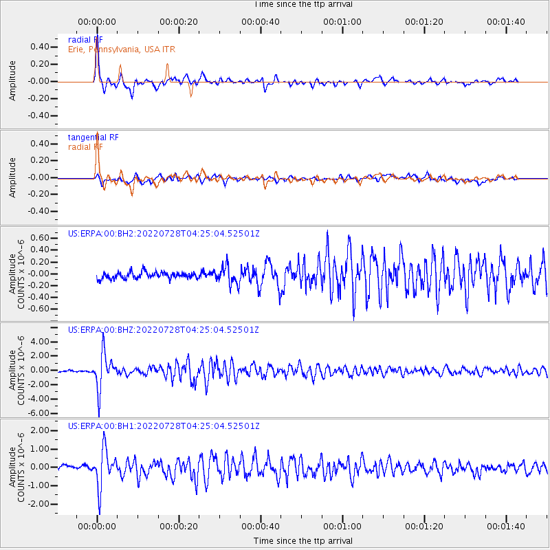
ERPA Erie, Pennsylvania, USA |
| Lat/Lon: |
42.12 N/79.99 W |
| Elevation: |
306 m |
|
| Distance: |
64.4 deg |
| Az: |
352.049 deg |
| Baz: |
170.059 deg |
| Ray Param: |
0.05886535 |
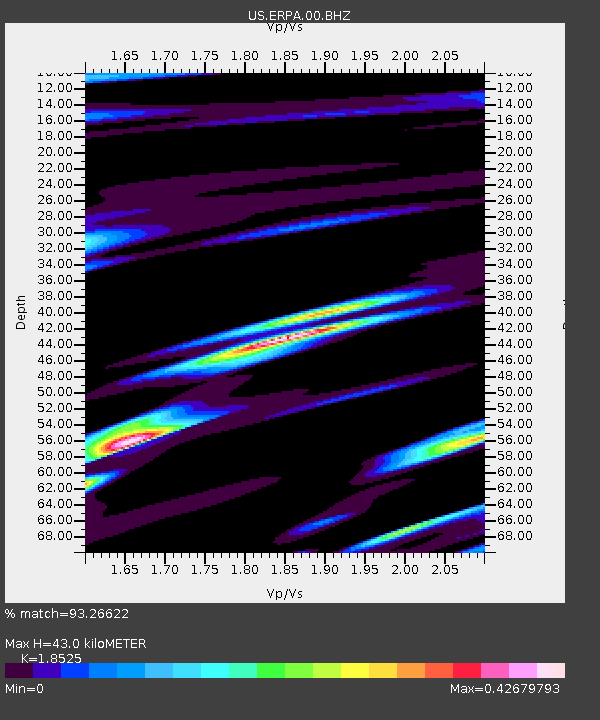
| Estimated Moho Depth: |
43.0 km |
| Estimated Crust Vp/Vs: |
1.85 |
| Assumed Crust Vp: |
6.419 km/s |
| Estimated Crust Vs: |
3.465 km/s |
| Estimated Crust Poisson's Ratio: |
0.29 |
|
| Radial Match: |
93.26622 % |
| Radial Bump: |
390 |
| Transverse Match: |
79.753204 % |
| Transverse Bump: |
400 |
| SOD ConfigId: |
28764291 |
| Insert Time: |
2022-08-11 05:11:44.133 +0000 |
| GWidth: |
2.5 |
| Max Bumps: |
400 |
| Tol: |
0.001 |
|
Signal To Noise
| Channel | StoN | STA | LTA |
| US:ERPA:00:BHZ:20220728T04:25:04.52501Z | 25.674942 | 2.5098993E-6 | 9.775677E-8 |
| US:ERPA:00:BH1:20220728T04:25:04.52501Z | 9.089675 | 1.0453332E-6 | 1.1500226E-7 |
| US:ERPA:00:BH2:20220728T04:25:04.52501Z | 2.8516202 | 1.538381E-7 | 5.3947613E-8 |
| Arrivals |
| Ps | 5.9 SECOND |
| PpPs | 18 SECOND |
| PsPs/PpSs | 24 SECOND |


