You are here: Home > Network List > US - United States National Seismic Network Stations List
> Station GLMI Grayling, Michigan, USA > Earthquake Result Viewer
GLMI Grayling, Michigan, USA - Earthquake Result Viewer
| Earthquake location: |
Near Coast Of Northern Chile |
| Earthquake latitude/longitude: |
-21.9/-70.3 |
| Earthquake time(UTC): |
2022/07/28 (209) 04:15:05 GMT |
| Earthquake Depth: |
54 km |
| Earthquake Magnitude: |
6.1 mww |
| Earthquake Catalog/Contributor: |
NEIC PDE/us |
|
| Network: |
US United States National Seismic Network |
| Station: |
GLMI Grayling, Michigan, USA |
| Lat/Lon: |
44.82 N/84.62 W |
| Elevation: |
387 m |
|
| Distance: |
67.7 deg |
| Az: |
349.066 deg |
| Baz: |
165.672 deg |
| Ray Param: |
0.056677528 |
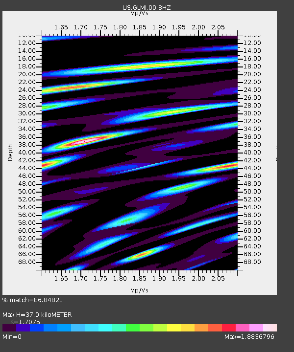
| Estimated Moho Depth: |
37.0 km |
| Estimated Crust Vp/Vs: |
1.71 |
| Assumed Crust Vp: |
6.483 km/s |
| Estimated Crust Vs: |
3.797 km/s |
| Estimated Crust Poisson's Ratio: |
0.24 |
|
| Radial Match: |
86.84821 % |
| Radial Bump: |
400 |
| Transverse Match: |
83.011284 % |
| Transverse Bump: |
400 |
| SOD ConfigId: |
28764291 |
| Insert Time: |
2022-08-11 05:11:46.194 +0000 |
| GWidth: |
2.5 |
| Max Bumps: |
400 |
| Tol: |
0.001 |
|

Signal To Noise
| Channel | StoN | STA | LTA |
| US:GLMI:00:BHZ:20220728T04:25:25.975022Z | 16.229828 | 1.8658137E-6 | 1.14962006E-7 |
| US:GLMI:00:BH1:20220728T04:25:25.975022Z | 5.550977 | 1.1750335E-6 | 2.1168047E-7 |
| US:GLMI:00:BH2:20220728T04:25:25.975022Z | 3.22964 | 7.641215E-7 | 2.3659649E-7 |
| Arrivals |
| Ps | 4.2 SECOND |
| PpPs | 15 SECOND |
| PsPs/PpSs | 19 SECOND |


