You are here: Home > Network List > UW - Pacific Northwest Regional Seismic Network Stations List
> Station PAN4H Panhandle 4H Camp, Shelton, WA, USA > Earthquake Result Viewer
PAN4H Panhandle 4H Camp, Shelton, WA, USA - Earthquake Result Viewer
| Earthquake location: |
Near Coast Of Northern Chile |
| Earthquake latitude/longitude: |
-21.9/-70.3 |
| Earthquake time(UTC): |
2022/07/28 (209) 04:15:05 GMT |
| Earthquake Depth: |
54 km |
| Earthquake Magnitude: |
6.1 mww |
| Earthquake Catalog/Contributor: |
NEIC PDE/us |
|
| Network: |
UW Pacific Northwest Regional Seismic Network |
| Station: |
PAN4H Panhandle 4H Camp, Shelton, WA, USA |
| Lat/Lon: |
47.18 N/123.27 W |
| Elevation: |
132 m |
|
| Distance: |
83.7 deg |
| Az: |
326.793 deg |
| Baz: |
131.809 deg |
| Ray Param: |
0.04592899 |
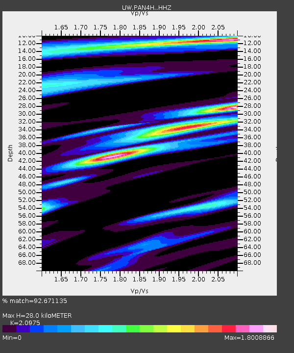
| Estimated Moho Depth: |
28.0 km |
| Estimated Crust Vp/Vs: |
2.10 |
| Assumed Crust Vp: |
6.566 km/s |
| Estimated Crust Vs: |
3.13 km/s |
| Estimated Crust Poisson's Ratio: |
0.35 |
|
| Radial Match: |
92.671135 % |
| Radial Bump: |
371 |
| Transverse Match: |
89.71182 % |
| Transverse Bump: |
400 |
| SOD ConfigId: |
28764291 |
| Insert Time: |
2022-08-11 05:16:02.367 +0000 |
| GWidth: |
2.5 |
| Max Bumps: |
400 |
| Tol: |
0.001 |
|

Signal To Noise
| Channel | StoN | STA | LTA |
| UW:PAN4H: :HHZ:20220728T04:26:56.86998Z | 24.839504 | 2.4917194E-6 | 1.0031277E-7 |
| UW:PAN4H: :HHN:20220728T04:26:56.86998Z | 5.5008483 | 5.4394576E-7 | 9.888398E-8 |
| UW:PAN4H: :HHE:20220728T04:26:56.86998Z | 6.3758526 | 5.8639637E-7 | 9.1971444E-8 |
| Arrivals |
| Ps | 4.8 SECOND |
| PpPs | 13 SECOND |
| PsPs/PpSs | 18 SECOND |


