You are here: Home > Network List > UW - Pacific Northwest Regional Seismic Network Stations List
> Station PASS Maple Falls, WA, USA > Earthquake Result Viewer
PASS Maple Falls, WA, USA - Earthquake Result Viewer
| Earthquake location: |
Near Coast Of Northern Chile |
| Earthquake latitude/longitude: |
-21.9/-70.3 |
| Earthquake time(UTC): |
2022/07/28 (209) 04:15:05 GMT |
| Earthquake Depth: |
54 km |
| Earthquake Magnitude: |
6.1 mww |
| Earthquake Catalog/Contributor: |
NEIC PDE/us |
|
| Network: |
UW Pacific Northwest Regional Seismic Network |
| Station: |
PASS Maple Falls, WA, USA |
| Lat/Lon: |
49.00 N/122.09 W |
| Elevation: |
174 m |
|
| Distance: |
84.3 deg |
| Az: |
328.686 deg |
| Baz: |
132.886 deg |
| Ray Param: |
0.045481436 |
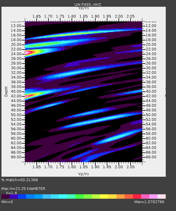
| Estimated Moho Depth: |
23.25 km |
| Estimated Crust Vp/Vs: |
1.60 |
| Assumed Crust Vp: |
6.566 km/s |
| Estimated Crust Vs: |
4.104 km/s |
| Estimated Crust Poisson's Ratio: |
0.18 |
|
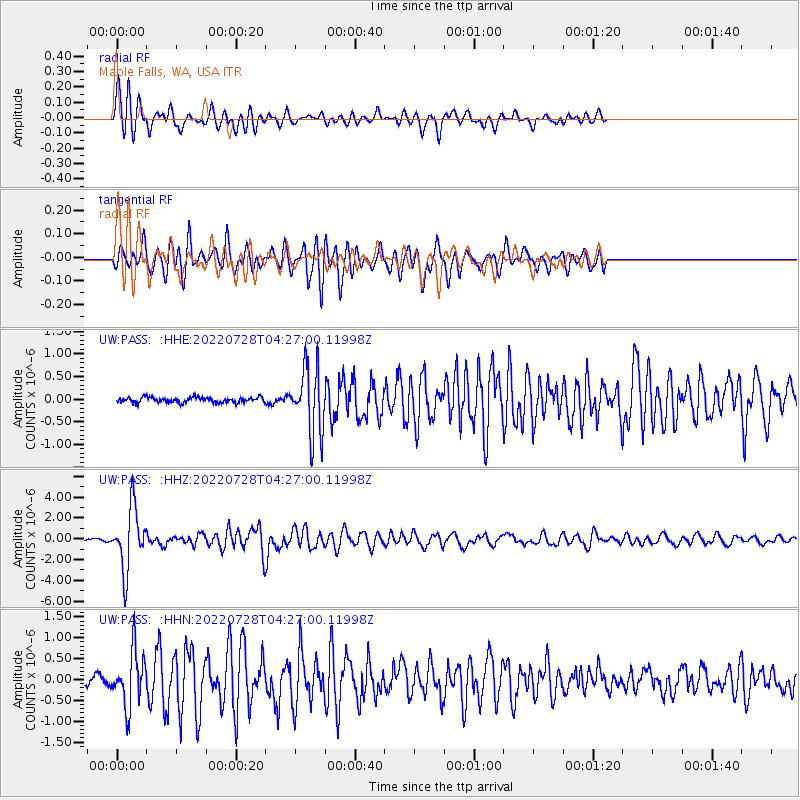
| Radial Match: |
80.21386 % |
| Radial Bump: |
400 |
| Transverse Match: |
75.96455 % |
| Transverse Bump: |
400 |
| SOD ConfigId: |
28764291 |
| Insert Time: |
2022-08-11 05:16:05.597 +0000 |
| GWidth: |
2.5 |
| Max Bumps: |
400 |
| Tol: |
0.001 |
|
Signal To Noise
| Channel | StoN | STA | LTA |
| UW:PASS: :HHZ:20220728T04:27:00.11998Z | 32.499165 | 2.933151E-6 | 9.0253124E-8 |
| UW:PASS: :HHN:20220728T04:27:00.11998Z | 8.195606 | 6.54769E-7 | 7.9892686E-8 |
| UW:PASS: :HHE:20220728T04:27:00.11998Z | 12.665804 | 7.224229E-7 | 5.7037273E-8 |
| Arrivals |
| Ps | 2.2 SECOND |
| PpPs | 8.9 SECOND |
| PsPs/PpSs | 11 SECOND |


