You are here: Home > Network List > UW - Pacific Northwest Regional Seismic Network Stations List
> Station COWL Weyerhaeuser Mt St Helens Tree Farm, Lewis County, WA, USA > Earthquake Result Viewer
COWL Weyerhaeuser Mt St Helens Tree Farm, Lewis County, WA, USA - Earthquake Result Viewer
| Earthquake location: |
Near Coast Of Northern Chile |
| Earthquake latitude/longitude: |
-21.9/-70.3 |
| Earthquake time(UTC): |
2022/07/28 (209) 04:15:05 GMT |
| Earthquake Depth: |
54 km |
| Earthquake Magnitude: |
6.1 mww |
| Earthquake Catalog/Contributor: |
NEIC PDE/us |
|
| Network: |
UW Pacific Northwest Regional Seismic Network |
| Station: |
COWL Weyerhaeuser Mt St Helens Tree Farm, Lewis County, WA, USA |
| Lat/Lon: |
46.48 N/122.66 W |
| Elevation: |
183 m |
|
| Distance: |
82.9 deg |
| Az: |
326.554 deg |
| Baz: |
132.221 deg |
| Ray Param: |
0.046476483 |
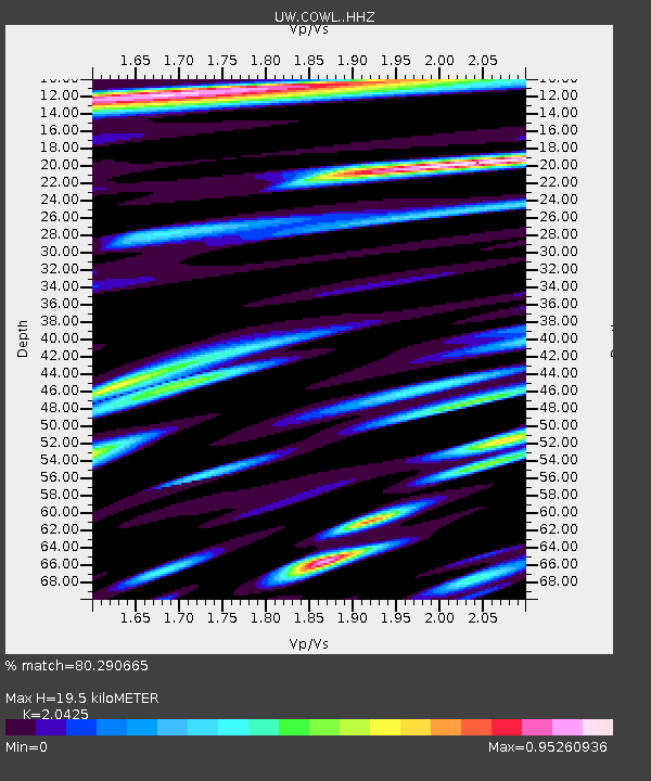
| Estimated Moho Depth: |
19.5 km |
| Estimated Crust Vp/Vs: |
2.04 |
| Assumed Crust Vp: |
6.566 km/s |
| Estimated Crust Vs: |
3.215 km/s |
| Estimated Crust Poisson's Ratio: |
0.34 |
|
| Radial Match: |
80.290665 % |
| Radial Bump: |
400 |
| Transverse Match: |
73.937 % |
| Transverse Bump: |
400 |
| SOD ConfigId: |
28764291 |
| Insert Time: |
2022-08-11 05:19:01.522 +0000 |
| GWidth: |
2.5 |
| Max Bumps: |
400 |
| Tol: |
0.001 |
|

Signal To Noise
| Channel | StoN | STA | LTA |
| UW:COWL: :HHZ:20220728T04:26:52.91002Z | 27.249504 | 4.2272204E-6 | 1.551302E-7 |
| UW:COWL: :HHN:20220728T04:26:52.91002Z | 1.5098432 | 4.5025527E-7 | 2.9821325E-7 |
| UW:COWL: :HHE:20220728T04:26:52.91002Z | 5.9624944 | 1.3062719E-6 | 2.1908146E-7 |
| Arrivals |
| Ps | 3.2 SECOND |
| PpPs | 8.8 SECOND |
| PsPs/PpSs | 12 SECOND |


