You are here: Home > Network List > AK - Alaska Regional Network Stations List
> Station J17K VABM Dome, AK, USA > Earthquake Result Viewer
J17K VABM Dome, AK, USA - Earthquake Result Viewer
| Earthquake location: |
Eastern New Guinea Reg., P.N.G. |
| Earthquake latitude/longitude: |
-7.0/146.7 |
| Earthquake time(UTC): |
2022/07/28 (209) 18:28:22 GMT |
| Earthquake Depth: |
10 km |
| Earthquake Magnitude: |
5.8 mww |
| Earthquake Catalog/Contributor: |
NEIC PDE/us |
|
| Network: |
AK Alaska Regional Network |
| Station: |
J17K VABM Dome, AK, USA |
| Lat/Lon: |
63.40 N/159.08 W |
| Elevation: |
323 m |
|
| Distance: |
81.2 deg |
| Az: |
21.679 deg |
| Baz: |
234.529 deg |
| Ray Param: |
0.047758162 |
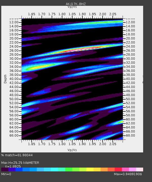
| Estimated Moho Depth: |
25.25 km |
| Estimated Crust Vp/Vs: |
1.89 |
| Assumed Crust Vp: |
6.276 km/s |
| Estimated Crust Vs: |
3.316 km/s |
| Estimated Crust Poisson's Ratio: |
0.31 |
|
| Radial Match: |
81.98044 % |
| Radial Bump: |
400 |
| Transverse Match: |
62.276703 % |
| Transverse Bump: |
400 |
| SOD ConfigId: |
28764291 |
| Insert Time: |
2022-08-11 18:33:22.889 +0000 |
| GWidth: |
2.5 |
| Max Bumps: |
400 |
| Tol: |
0.001 |
|

Signal To Noise
| Channel | StoN | STA | LTA |
| AK:J17K: :BHZ:20220728T18:40:07.319988Z | 3.2984254 | 2.5966878E-7 | 7.8725066E-8 |
| AK:J17K: :BHN:20220728T18:40:07.319988Z | 1.2409424 | 6.601122E-8 | 5.3194427E-8 |
| AK:J17K: :BHE:20220728T18:40:07.319988Z | 1.6590191 | 1.1755708E-7 | 7.0859386E-8 |
| Arrivals |
| Ps | 3.7 SECOND |
| PpPs | 11 SECOND |
| PsPs/PpSs | 15 SECOND |


