You are here: Home > Network List > TX - Texas Seismological Network Stations List
> Station PLPT Palo Pinto > Earthquake Result Viewer
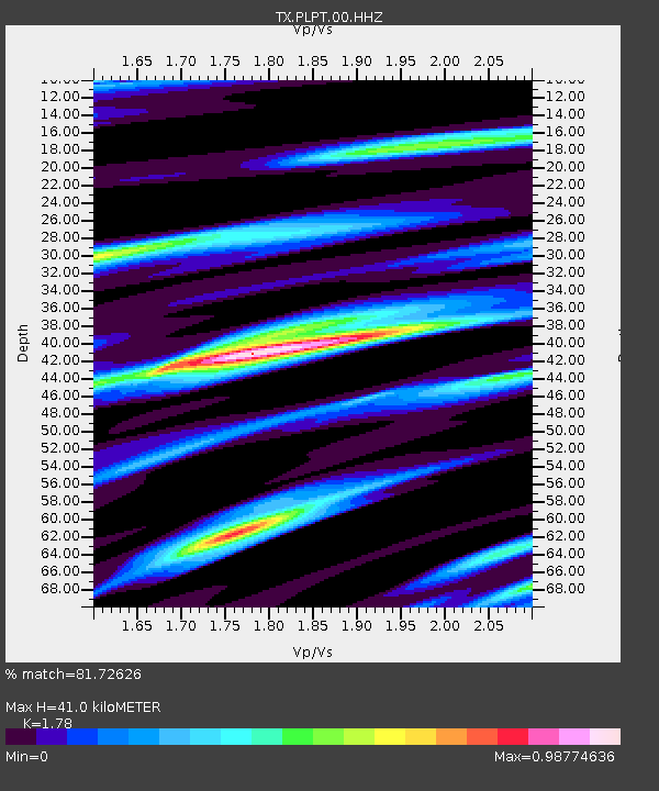
PLPT Palo Pinto - Earthquake Result Viewer
| Earthquake location: |
Near Coast Of Venezuela |
| Earthquake latitude/longitude: |
10.6/-62.9 |
| Earthquake time(UTC): |
2018/08/22 (234) 13:27:47 GMT |
| Earthquake Depth: |
98 km |
| Earthquake Magnitude: |
5.8 Mww |
| Earthquake Catalog/Contributor: |
NEIC PDE/us |
|
| Network: |
TX Texas Seismological Network |
| Station: |
PLPT Palo Pinto |
| Lat/Lon: |
32.81 N/98.32 W |
| Elevation: |
336 m |
|
| Distance: |
39.3 deg |
| Az: |
309.704 deg |
| Baz: |
116.067 deg |
| Ray Param: |
0.0747136 |
| Estimated Moho Depth: |
41.0 km |
| Estimated Crust Vp/Vs: |
1.78 |
| Assumed Crust Vp: |
6.426 km/s |
| Estimated Crust Vs: |
3.61 km/s |
| Estimated Crust Poisson's Ratio: |
0.27 |
|
| Radial Match: |
81.72626 % |
| Radial Bump: |
319 |
| Transverse Match: |
56.534245 % |
| Transverse Bump: |
400 |
| SOD ConfigId: |
2825771 |
| Insert Time: |
2018-09-05 13:46:13.976 +0000 |
| GWidth: |
2.5 |
| Max Bumps: |
400 |
| Tol: |
0.001 |
|

Signal To Noise
| Channel | StoN | STA | LTA |
| TX:PLPT:00:HHZ:20180822T13:34:36.960005Z | 10.72215 | 6.880334E-7 | 6.4169356E-8 |
| TX:PLPT:00:HH1:20180822T13:34:36.960005Z | 7.0057187 | 4.2967926E-7 | 6.133264E-8 |
| TX:PLPT:00:HH2:20180822T13:34:36.960005Z | 3.4143085 | 1.937823E-7 | 5.675594E-8 |
| Arrivals |
| Ps | 5.3 SECOND |
| PpPs | 17 SECOND |
| PsPs/PpSs | 22 SECOND |


