You are here: Home > Network List > AK - Alaska Regional Network Stations List
> Station G17K Kiwalik Mountain, AK, USA > Earthquake Result Viewer
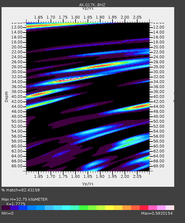
G17K Kiwalik Mountain, AK, USA - Earthquake Result Viewer
| Earthquake location: |
Southeast Of Honshu, Japan |
| Earthquake latitude/longitude: |
32.5/142.4 |
| Earthquake time(UTC): |
2022/07/28 (209) 19:52:27 GMT |
| Earthquake Depth: |
10 km |
| Earthquake Magnitude: |
5.4 Mww |
| Earthquake Catalog/Contributor: |
NEIC PDE/us |
|
| Network: |
AK Alaska Regional Network |
| Station: |
G17K Kiwalik Mountain, AK, USA |
| Lat/Lon: |
65.50 N/160.65 W |
| Elevation: |
338 m |
|
| Distance: |
47.3 deg |
| Az: |
28.39 deg |
| Baz: |
254.506 deg |
| Ray Param: |
0.07008955 |
| Estimated Moho Depth: |
32.75 km |
| Estimated Crust Vp/Vs: |
1.78 |
| Assumed Crust Vp: |
6.276 km/s |
| Estimated Crust Vs: |
3.531 km/s |
| Estimated Crust Poisson's Ratio: |
0.27 |
|
| Radial Match: |
82.43159 % |
| Radial Bump: |
400 |
| Transverse Match: |
66.74117 % |
| Transverse Bump: |
400 |
| SOD ConfigId: |
28764291 |
| Insert Time: |
2022-08-11 19:58:11.333 +0000 |
| GWidth: |
2.5 |
| Max Bumps: |
400 |
| Tol: |
0.001 |
|

Signal To Noise
| Channel | StoN | STA | LTA |
| AK:G17K: :BHZ:20220728T20:00:30.339993Z | 9.1135235 | 3.5912893E-7 | 3.9406157E-8 |
| AK:G17K: :BHN:20220728T20:00:30.339993Z | 1.3176761 | 5.6774454E-8 | 4.3086807E-8 |
| AK:G17K: :BHE:20220728T20:00:30.339993Z | 5.242667 | 2.159184E-7 | 4.118484E-8 |
| Arrivals |
| Ps | 4.3 SECOND |
| PpPs | 14 SECOND |
| PsPs/PpSs | 18 SECOND |


