You are here: Home > Network List > US - United States National Seismic Network Stations List
> Station HAWA Hanford, Washington, USA > Earthquake Result Viewer
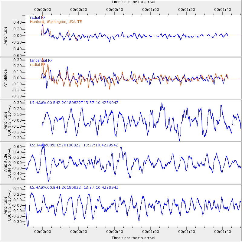
HAWA Hanford, Washington, USA - Earthquake Result Viewer
*The percent match for this event was below the threshold and hence no stack was calculated.
| Earthquake location: |
Near Coast Of Venezuela |
| Earthquake latitude/longitude: |
10.6/-62.9 |
| Earthquake time(UTC): |
2018/08/22 (234) 13:27:47 GMT |
| Earthquake Depth: |
98 km |
| Earthquake Magnitude: |
5.8 Mww |
| Earthquake Catalog/Contributor: |
NEIC PDE/us |
|
| Network: |
US United States National Seismic Network |
| Station: |
HAWA Hanford, Washington, USA |
| Lat/Lon: |
46.39 N/119.53 W |
| Elevation: |
364 m |
|
| Distance: |
59.6 deg |
| Az: |
317.924 deg |
| Baz: |
107.84 deg |
| Ray Param: |
$rayparam |
*The percent match for this event was below the threshold and hence was not used in the summary stack. |
|
| Radial Match: |
57.17067 % |
| Radial Bump: |
400 |
| Transverse Match: |
63.3054 % |
| Transverse Bump: |
400 |
| SOD ConfigId: |
2825771 |
| Insert Time: |
2018-09-05 13:47:15.699 +0000 |
| GWidth: |
2.5 |
| Max Bumps: |
400 |
| Tol: |
0.001 |
|
Signal To Noise
| Channel | StoN | STA | LTA |
| US:HAWA:00:BHZ:20180822T13:37:10.423994Z | 3.2467923 | 4.7147168E-7 | 1.4521153E-7 |
| US:HAWA:00:BH1:20180822T13:37:10.423994Z | 0.6581979 | 8.4368764E-8 | 1.2818147E-7 |
| US:HAWA:00:BH2:20180822T13:37:10.423994Z | 0.90120447 | 1.0103175E-7 | 1.1210747E-7 |
| Arrivals |
| Ps | |
| PpPs | |
| PsPs/PpSs | |


