You are here: Home > Network List > XK01 - Reflections under the Scottish Highlands Stations List
> Station ROGR Rogart > Earthquake Result Viewer
ROGR Rogart - Earthquake Result Viewer
| Earthquake location: |
Northeastern China |
| Earthquake latitude/longitude: |
44.8/129.9 |
| Earthquake time(UTC): |
2002/09/15 (258) 08:39:32 GMT |
| Earthquake Depth: |
586 km |
| Earthquake Magnitude: |
5.8 MB, 6.4 MW, 6.4 MW |
| Earthquake Catalog/Contributor: |
WHDF/NEIC |
|
| Network: |
XK Reflections under the Scottish Highlands |
| Station: |
ROGR Rogart |
| Lat/Lon: |
58.03 N/4.17 W |
| Elevation: |
229 m |
|
| Distance: |
70.6 deg |
| Az: |
336.106 deg |
| Baz: |
32.794 deg |
| Ray Param: |
0.05283894 |
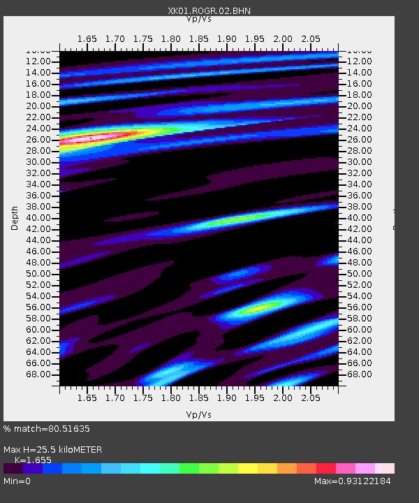
| Estimated Moho Depth: |
25.5 km |
| Estimated Crust Vp/Vs: |
1.65 |
| Assumed Crust Vp: |
6.24 km/s |
| Estimated Crust Vs: |
3.77 km/s |
| Estimated Crust Poisson's Ratio: |
0.21 |
|
| Radial Match: |
80.51635 % |
| Radial Bump: |
400 |
| Transverse Match: |
74.12966 % |
| Transverse Bump: |
400 |
| SOD ConfigId: |
16820 |
| Insert Time: |
2010-03-09 23:02:02.292 +0000 |
| GWidth: |
2.5 |
| Max Bumps: |
400 |
| Tol: |
0.001 |
|

Signal To Noise
| Channel | StoN | STA | LTA |
| XK:ROGR:02:BHN:20020915T08:49:19.142017Z | 3.756793 | 5.9277E-7 | 1.5778616E-7 |
| XK:ROGR:02:BHE:20020915T08:49:19.142017Z | 2.8886278 | 5.7090887E-7 | 1.9764016E-7 |
| XK:ROGR:02:BHZ:20020915T08:49:19.142017Z | 12.659186 | 2.2044833E-6 | 1.74141E-7 |
| Arrivals |
| Ps | 2.8 SECOND |
| PpPs | 10 SECOND |
| PsPs/PpSs | 13 SECOND |


