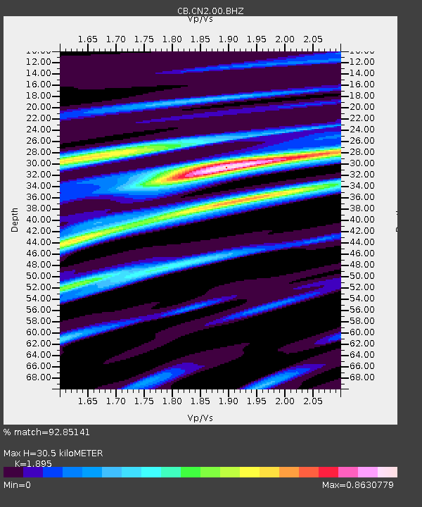
CN2 Changchun,Jilin Province - Earthquake Result Viewer

Earthquake location: Irian Jaya Region, Indonesia
Earthquake latitude/longitude: -0.5/132.9
Earthquake time(UTC): 2009/08/02 (214) 08:54:35 GMT
Earthquake Depth: 35 km
Earthquake Magnitude: 5.8 MB, 5.8 MS, 6.1 MW, 6.0 MW
Earthquake Catalog/Contributor: WHDF/NEIC
Network: CB China National Seismic Network
Station: CN2 Changchun,Jilin Province
Lat/Lon: 43.48 N/125.26 E
Elevation: 223 m
Distance: 44.3 deg
Az: 352.036 deg
Baz: 169.028 deg
Ray Param: 0.07194135
Estimated Moho Depth: 30.5 km
Estimated Crust Vp/Vs: 1.89
Assumed Crust Vp: 6.459 km/s
Estimated Crust Vs: 3.409 km/s
Estimated Crust Poisson's Ratio: 0.31
Radial Match: 92.85141 %
Radial Bump: 400
Transverse Match: 80.620674 %
Transverse Bump: 400
SOD ConfigId: 2622
Insert Time: 2010-03-09 23:03:03.585 +0000
GWidth: 2.5
Max Bumps: 400
Tol: 0.001

Signal To Noise

ChannelStoNSTALTA
CB:CN2:00:BHZ:20090802T09:02:11.349011Z9.4209446.60063E-77.006336E-8
CB:CN2:00:BHN:20090802T09:02:11.349011Z3.5939653.3405706E-79.294945E-8
CB:CN2:00:BHE:20090802T09:02:11.349011Z1.1180577.972206E-87.130411E-8
Arrivals
Ps4.5 SECOND
PpPs13 SECOND
PsPs/PpSs17 SECOND