You are here: Home > Network List > US - United States National Seismic Network Stations List
> Station MNTX Cornudas Mountains, Texas, USA > Earthquake Result Viewer
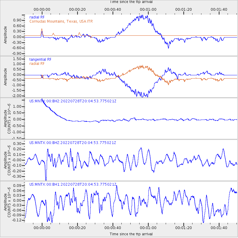
MNTX Cornudas Mountains, Texas, USA - Earthquake Result Viewer
*The percent match for this event was below the threshold and hence no stack was calculated.
| Earthquake location: |
Southeast Of Honshu, Japan |
| Earthquake latitude/longitude: |
32.5/142.4 |
| Earthquake time(UTC): |
2022/07/28 (209) 19:52:27 GMT |
| Earthquake Depth: |
10 km |
| Earthquake Magnitude: |
5.4 Mww |
| Earthquake Catalog/Contributor: |
NEIC PDE/us |
|
| Network: |
US United States National Seismic Network |
| Station: |
MNTX Cornudas Mountains, Texas, USA |
| Lat/Lon: |
31.70 N/105.38 W |
| Elevation: |
405 m |
|
| Distance: |
89.6 deg |
| Az: |
52.117 deg |
| Baz: |
308.507 deg |
| Ray Param: |
$rayparam |
*The percent match for this event was below the threshold and hence was not used in the summary stack. |
|
| Radial Match: |
64.49577 % |
| Radial Bump: |
400 |
| Transverse Match: |
60.694355 % |
| Transverse Bump: |
400 |
| SOD ConfigId: |
28764291 |
| Insert Time: |
2022-08-11 20:34:16.258 +0000 |
| GWidth: |
2.5 |
| Max Bumps: |
400 |
| Tol: |
0.001 |
|
Signal To Noise
| Channel | StoN | STA | LTA |
| US:MNTX:00:BHZ:20220728T20:04:53.775021Z | 2.9369426 | 1.4492086E-7 | 4.9344127E-8 |
| US:MNTX:00:BH1:20220728T20:04:53.775021Z | 0.94532835 | 1.7890007E-7 | 1.8924648E-7 |
| US:MNTX:00:BH2:20220728T20:04:53.775021Z | 0.8433448 | 4.0994982E-7 | 4.860999E-7 |
| Arrivals |
| Ps | |
| PpPs | |
| PsPs/PpSs | |


