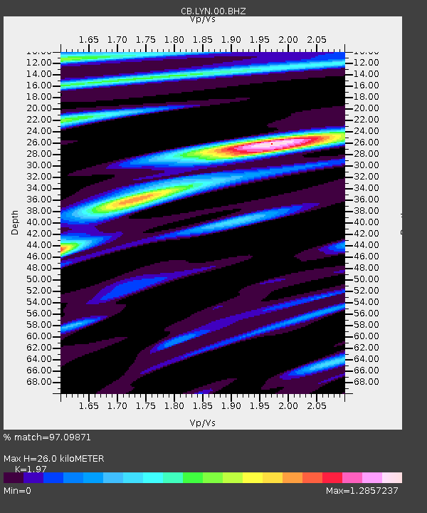
LYN Luoyang,Henan Province - Earthquake Result Viewer

Earthquake location: Southern Sumatra, Indonesia
Earthquake latitude/longitude: -3.1/100.5
Earthquake time(UTC): 2009/04/15 (105) 20:01:34 GMT
Earthquake Depth: 20 km
Earthquake Magnitude: 6.1 MB, 6.4 MS, 6.4 MW, 6.2 MW
Earthquake Catalog/Contributor: WHDF/NEIC
Network: CB China National Seismic Network
Station: LYN Luoyang,Henan Province
Lat/Lon: 34.55 N/112.47 E
Elevation: 170 m
Distance: 39.1 deg
Az: 15.78 deg
Baz: 199.207 deg
Ray Param: 0.07513572
Estimated Moho Depth: 26.0 km
Estimated Crust Vp/Vs: 1.97
Assumed Crust Vp: 6.155 km/s
Estimated Crust Vs: 3.124 km/s
Estimated Crust Poisson's Ratio: 0.33
Radial Match: 97.09871 %
Radial Bump: 400
Transverse Match: 90.20124 %
Transverse Bump: 400
SOD ConfigId: 2760
Insert Time: 2010-03-09 23:06:13.728 +0000
GWidth: 2.5
Max Bumps: 400
Tol: 0.001

Signal To Noise

ChannelStoNSTALTA
CB:LYN:00:BHZ:20090415T20:08:29.70901Z92.508441.0451294E-51.1297665E-7
CB:LYN:00:BHN:20090415T20:08:29.70901Z49.8057174.7124345E-69.461633E-8
CB:LYN:00:BHE:20090415T20:08:29.70901Z30.2906672.105011E-66.9493716E-8
Arrivals
Ps4.3 SECOND
PpPs12 SECOND
PsPs/PpSs16 SECOND