You are here: Home > Network List > IW - Intermountain West Stations List
> Station MOOW Moose Ponds, Wyoming, USA > Earthquake Result Viewer
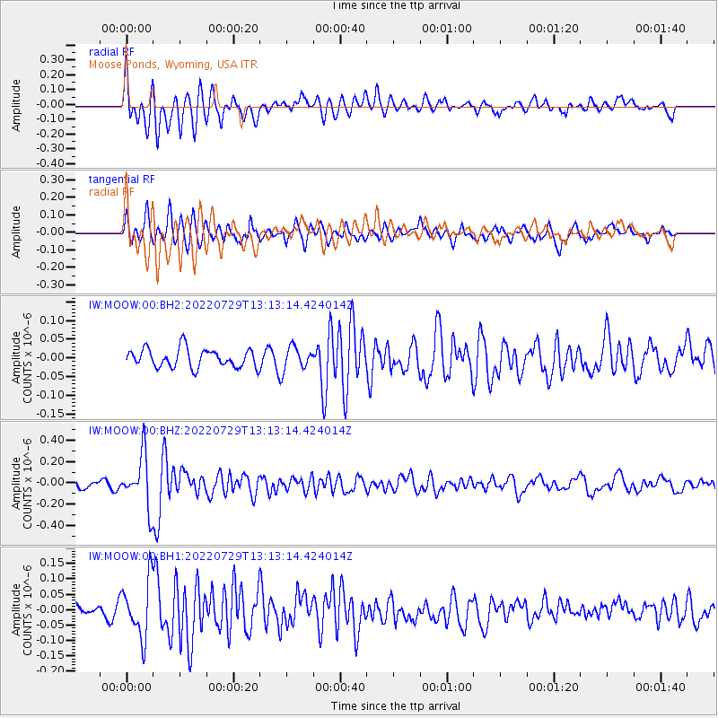
MOOW Moose Ponds, Wyoming, USA - Earthquake Result Viewer
*The percent match for this event was below the threshold and hence no stack was calculated.
| Earthquake location: |
Russia-Mongolia Border Region |
| Earthquake latitude/longitude: |
50.4/90.6 |
| Earthquake time(UTC): |
2022/07/29 (210) 13:01:13 GMT |
| Earthquake Depth: |
10 km |
| Earthquake Magnitude: |
5.6 Mww |
| Earthquake Catalog/Contributor: |
NEIC PDE/us |
|
| Network: |
IW Intermountain West |
| Station: |
MOOW Moose Ponds, Wyoming, USA |
| Lat/Lon: |
43.75 N/110.74 W |
| Elevation: |
2128 m |
|
| Distance: |
84.4 deg |
| Az: |
15.385 deg |
| Baz: |
346.449 deg |
| Ray Param: |
$rayparam |
*The percent match for this event was below the threshold and hence was not used in the summary stack. |
|
| Radial Match: |
66.05293 % |
| Radial Bump: |
400 |
| Transverse Match: |
72.95953 % |
| Transverse Bump: |
400 |
| SOD ConfigId: |
28764291 |
| Insert Time: |
2022-08-12 13:32:28.487 +0000 |
| GWidth: |
2.5 |
| Max Bumps: |
400 |
| Tol: |
0.001 |
|
Signal To Noise
| Channel | StoN | STA | LTA |
| IW:MOOW:00:BHZ:20220729T13:13:14.424014Z | 10.069098 | 2.5096503E-7 | 2.4924281E-8 |
| IW:MOOW:00:BH1:20220729T13:13:14.424014Z | 3.039459 | 9.3852854E-8 | 3.0878144E-8 |
| IW:MOOW:00:BH2:20220729T13:13:14.424014Z | 1.2170452 | 3.0207058E-8 | 2.4819999E-8 |
| Arrivals |
| Ps | |
| PpPs | |
| PsPs/PpSs | |


