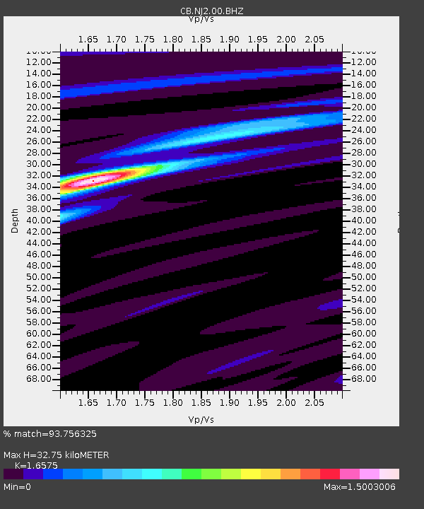
NJ2 Nanjing,Jiangsu Province - Earthquake Result Viewer
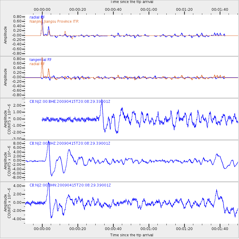
Earthquake location: Southern Sumatra, Indonesia
Earthquake latitude/longitude: -3.1/100.5
Earthquake time(UTC): 2009/04/15 (105) 20:01:34 GMT
Earthquake Depth: 20 km
Earthquake Magnitude: 6.1 MB, 6.4 MS, 6.4 MW, 6.2 MW
Earthquake Catalog/Contributor: WHDF/NEIC
Network: CB China National Seismic Network
Station: NJ2 Nanjing,Jiangsu Province
Lat/Lon: 32.05 N/118.85 E
Elevation: 45 m
Distance: 39.1 deg
Az: 25.134 deg
Baz: 209.964 deg
Ray Param: 0.0751581
Estimated Moho Depth: 32.75 km
Estimated Crust Vp/Vs: 1.66
Assumed Crust Vp: 6.276 km/s
Estimated Crust Vs: 3.786 km/s
Estimated Crust Poisson's Ratio: 0.21
Radial Match: 93.756325 %
Radial Bump: 240
Transverse Match: 78.51182 %
Transverse Bump: 400
SOD ConfigId: 2760
Insert Time: 2010-03-09 23:06:57.451 +0000
GWidth: 2.5
Max Bumps: 400
Tol: 0.001

Signal To Noise

ChannelStoNSTALTA
CB:NJ2:00:BHZ:20090415T20:08:29.39001Z38.723573.96634E-61.02427016E-7
CB:NJ2:00:BHN:20090415T20:08:29.39001Z10.7918842.08646E-61.9333602E-7
CB:NJ2:00:BHE:20090415T20:08:29.39001Z6.58920431.1376751E-61.7265742E-7
Arrivals
Ps3.7 SECOND
PpPs13 SECOND
PsPs/PpSs17 SECOND