You are here: Home > Network List > CB - China National Seismic Network Stations List
> Station WHN Wuhantai,Hubei Province > Earthquake Result Viewer
WHN Wuhantai,Hubei Province - Earthquake Result Viewer
| Earthquake location: |
Java, Indonesia |
| Earthquake latitude/longitude: |
-7.8/107.3 |
| Earthquake time(UTC): |
2009/09/02 (245) 07:55:01 GMT |
| Earthquake Depth: |
46 km |
| Earthquake Magnitude: |
6.8 MB, 7.0 MS, 7.0 MW, 7.0 MW |
| Earthquake Catalog/Contributor: |
WHDF/NEIC |
|
| Network: |
CB China National Seismic Network |
| Station: |
WHN Wuhantai,Hubei Province |
| Lat/Lon: |
30.54 N/114.35 E |
| Elevation: |
80 m |
|
| Distance: |
38.7 deg |
| Az: |
9.759 deg |
| Baz: |
191.227 deg |
| Ray Param: |
0.07529538 |
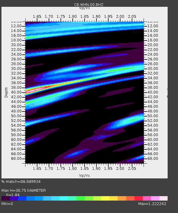
| Estimated Moho Depth: |
38.75 km |
| Estimated Crust Vp/Vs: |
1.64 |
| Assumed Crust Vp: |
6.276 km/s |
| Estimated Crust Vs: |
3.827 km/s |
| Estimated Crust Poisson's Ratio: |
0.20 |
|
| Radial Match: |
86.869934 % |
| Radial Bump: |
400 |
| Transverse Match: |
66.70939 % |
| Transverse Bump: |
400 |
| SOD ConfigId: |
2622 |
| Insert Time: |
2010-03-09 23:07:59.644 +0000 |
| GWidth: |
2.5 |
| Max Bumps: |
400 |
| Tol: |
0.001 |
|

Signal To Noise
| Channel | StoN | STA | LTA |
| CB:WHN:00:BHZ:20090902T08:01:50.138013Z | 69.90752 | 1.4476961E-5 | 2.0708734E-7 |
| CB:WHN:00:BHN:20090902T08:01:50.138013Z | 43.393227 | 7.389818E-6 | 1.7029889E-7 |
| CB:WHN:00:BHE:20090902T08:01:50.138013Z | 13.126199 | 2.1067765E-6 | 1.6050164E-7 |
| Arrivals |
| Ps | 4.3 SECOND |
| PpPs | 15 SECOND |
| PsPs/PpSs | 19 SECOND |


