You are here: Home > Network List > GS - US Geological Survey Networks Stations List
> Station DEC06 Boomer > Earthquake Result Viewer
DEC06 Boomer - Earthquake Result Viewer
| Earthquake location: |
Andreanof Islands, Aleutian Is. |
| Earthquake latitude/longitude: |
51.5/-177.9 |
| Earthquake time(UTC): |
2018/08/23 (235) 03:35:15 GMT |
| Earthquake Depth: |
44 km |
| Earthquake Magnitude: |
6.0 Ml |
| Earthquake Catalog/Contributor: |
NEIC PDE/us |
|
| Network: |
GS US Geological Survey Networks |
| Station: |
DEC06 Boomer |
| Lat/Lon: |
39.90 N/88.95 W |
| Elevation: |
215 m |
|
| Distance: |
59.5 deg |
| Az: |
63.227 deg |
| Baz: |
313.511 deg |
| Ray Param: |
0.06206055 |
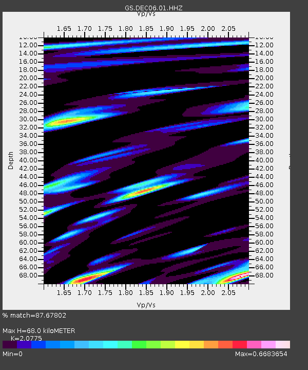
| Estimated Moho Depth: |
68.0 km |
| Estimated Crust Vp/Vs: |
2.08 |
| Assumed Crust Vp: |
6.444 km/s |
| Estimated Crust Vs: |
3.102 km/s |
| Estimated Crust Poisson's Ratio: |
0.35 |
|
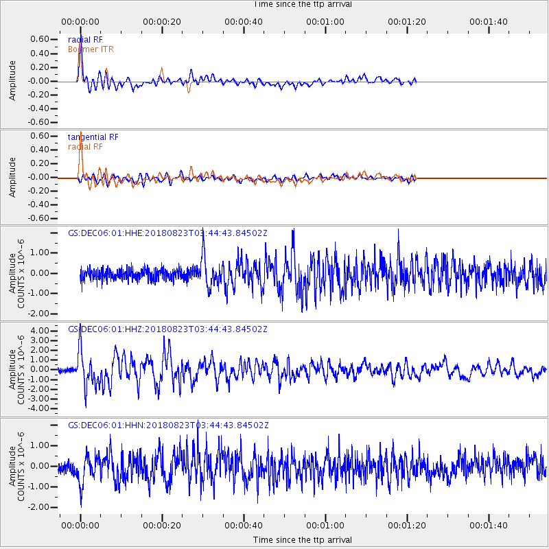
| Radial Match: |
87.67802 % |
| Radial Bump: |
400 |
| Transverse Match: |
77.478836 % |
| Transverse Bump: |
400 |
| SOD ConfigId: |
2825771 |
| Insert Time: |
2018-09-06 03:49:29.379 +0000 |
| GWidth: |
2.5 |
| Max Bumps: |
400 |
| Tol: |
0.001 |
|
Signal To Noise
| Channel | StoN | STA | LTA |
| GS:DEC06:01:HHZ:20180823T03:44:43.84502Z | 7.6780133 | 1.8664364E-6 | 2.4308844E-7 |
| GS:DEC06:01:HHN:20180823T03:44:43.84502Z | 2.3002224 | 6.800455E-7 | 2.956434E-7 |
| GS:DEC06:01:HHE:20180823T03:44:43.84502Z | 3.0930073 | 7.3543E-7 | 2.3777181E-7 |
| Arrivals |
| Ps | 12 SECOND |
| PpPs | 31 SECOND |
| PsPs/PpSs | 43 SECOND |


